Progress with BirdPix in the Western Cape during 2020

Southern Double-collared Sunbird

This is planned to be the first of many similar blogs. We are starting with an easy project, BirdPix, in my home province, Western Cape. It is still a bit experimental!

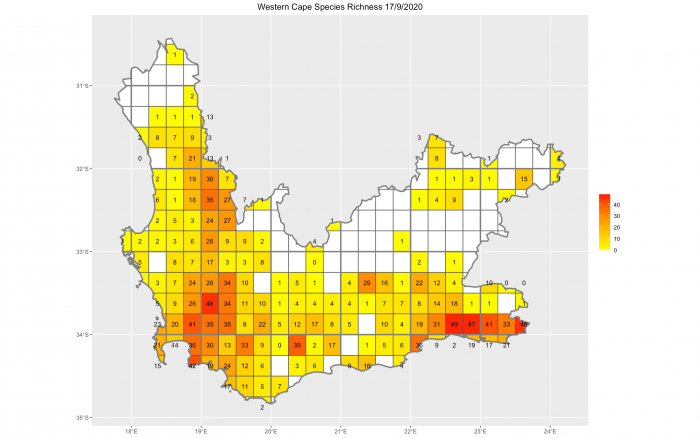
This map shows the number of bird species recorded for BirdPix in each quarter degree grid cell of the Western Cape on 28 December this year, very close to the end of 2020.

BirdPix in the Western Cape, 2020. The number in each grid cell is the total number of bird species recorded in the grid cell up to 28 December 2020

And this what this same map looked like a year ago, on 31 December 2019.

BirdPix in the Western Cape, 2019. The number in each grid cell is the total number of bird species recorded in the grid cell up to 28 December 2019

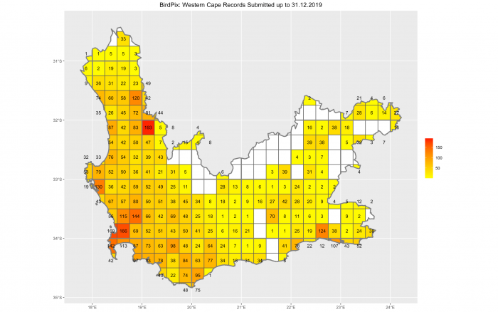
These two maps show impressive progress during 2020 for the total number of species in many grid cells.  And you have to work quite hard to find the grid cells where the year-end totals are the same!

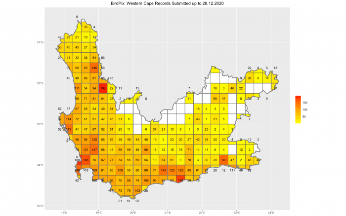
But the emphasis in the Virtual Museum has shifted from “species per grid cell, irrespective of when the records were made”, to keeping the database “refreshed”. The map below provides a quick measure of freshness. It shows the number of species per grid cell, for records uploaded in the year 2020.

BirdPix in the Western Cape in 2020 only. The number in each grid cell is the total number of bird species recorded in the grid cell, considering records uploaded to BirdPix between 1 January 2020 up to 28 December 2020 only

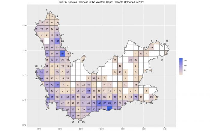
The logic here is that the more species uploaded for a grid cell in 2020, the more up-to-date the species list for that grid cell must be. We don’t know yet what this map will look like for other projects and for other provinces. But this has to be impressive! Some grid cells, those in darker shades of blue, had lots of species in 2020. Those with beige shades had only a few. But an awful lot of grid cells in the Western Cape were visited during the year.

The Cape Town grid cell had 169 species at the end of 2019 (second map). This had grown by 20 species to 189 at the end of 2020 (first map). But the total number of species submitted during 2020 was 135 (third map). This means that 20 of the 135 species were new to the grid cell, and that the remaining 115 species were used to do a 2020 refreshment of species last recorded in earlier years! This concept of “refreshing” old records is one that we are going to talk about more and more. There is a blog about this.

And here is a fairly subtle approach to measuring “up-to-dateness” in the Western Cape overall! For each grid cell, we find the date of the last record for each species. If species are “refreshed” regularly, this date will be recent. We next sort all the “last recorded” dates for all the species in a grid cell from oldest to most recent. Calculate the date in the middle. Half the species were last seen before this date, and half have been seen subsequently. We  want to keep this middle date as recent as possible. (Statisticians call this “middle date” the median, and there is a blog about this concept.)

Next, we take all the grid cells in a region (e.g. a province like the Western Cape) and we compute the middle dates (the medians) for all of them. We hope, on average, that these middle dates are pretty recent. To measure how recent they are overall, we calculate the middle date of all the middle dates in the region. We are happiest if this date is recent. We prefer this date to be recent, because if this median of medians is not too far in the past, it means that, overall, the species lists for the grid cells in the region are pretty up-to-date.

At the end of 2020, for BirdPix in the Western Cape, the median of the medians is 24 October 2018. In other words,  half the grid cells have their own medians before this date, and half of them have medians after this date. October 2018 is 26 months ago. So we can make the statement: BirdPix is, on average, 26 months behind the clock. Before we decide whether this is good or bad, we will need to do these calculations for lots of other projects and provinces. It will probably turn out to be awesomely excellent.

We can repeat this arithmetic, pretending we are have turned the clock back to December 2019, a year ago. The median of the medians was 14 December 2015. Gosh, this is 48 months previous to December 2019. In other words, at the end of 2019, BirdPix was 48 months behind the clock in the Western Cape. What this means is that, during 2020, BirdPix in the Western Cape “improved” from being 48 months behind the clock to being 26 months behind the clock. That is a 22-month improvement. That sounds pretty impressive.

New Year’s resolution for Team Virtual Museum

“Starting in my home grid cell on 1 January 2021, I will upload records to the Virtual Museum of as many species as possible (and I will be especially careful not to neglect the common species). Wherever I travel in 2021, I will do my best to keep the distribution maps up-to-date for as many species as possible.”

Southern Double-collared Sunbird
This photo illustrates the point that photos for the Virtual Museum do not have to be works of art. So long as the species in the photo is identifiable, it qualifies! But this Southern Double-collared Sunbird is pushing the patience of the expert panel to the limits. Here it is in BirdPix: http://vmus.adu.org.za/?vm=BirdPix-150313. It was the first record of this species in quarter degree grid cell 3418AD, at Cape Point, so it was a bit of a priority

Postscript: Finding the ruddy quarter degree grid cells

The frustrating thing about all these maps is this problem: “How do I find a particular grid cell on the ground?” Doing this is harder than it needs to be, because the clown who designed the system of codes for quarter degree grid cells ought to have been allowed to design only one more thing: his tombstone! It is a messy and unnecessarily complicated system. But we are stuck with it, so we have no choice but to get to grips with it. If you pick a grid cell in one of these maps, and want to work out its six character code, here is the recipe.

(1) Find the four digits for the one degree grid cell. To do this, first go up to the next thick line above your grid cell, and follow this line to the degrees number on the left edge of the map. In South Africa, there are always two digits. 33 is an example. They are the first two digits you need. Then go left from your chosen grid cell to the next thick line. The degrees number is on the bottom edge of the map. Also, two digits; numbers like 21. Run the four digits together. For the example above, the one degree grid cell is known as 3321.

(2) There are 16 quarter degree grid cells in the one degree grid cell. They are arranged in four rows and four columns, and each quarter degree grid cell has a code consisting of two letters (see the pattern below). Which row and which column is your grid cell in? Suppose it is in the third row and the second column. Use this pattern guide to find the two letter code for the grid cell in this position. Third row, second column is position CB. Add these letters onto the four digits for the one degree grid cell. So the code for the grid cell you are looking for is 3321CB. Gosh, that is not easy.

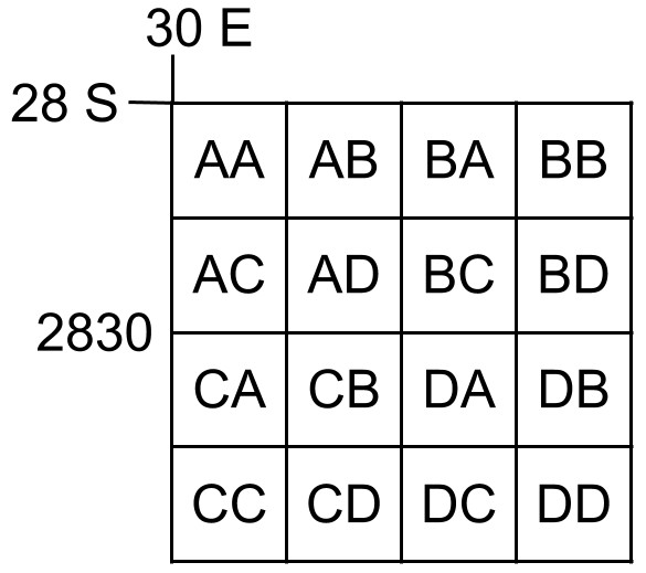
To find a list of the bird species that have been submitted to BirdPix for grid cell 3321CB, go to http://vmus.adu.org.za/vm_locus_map.php?vm=birdpix&locus=3321CB. You will discover that it needs a visit!

You can put any grid cell you need as the locus (ie adjust locus=3321CB to whatever you need). You can also change projects; eg replace vm=birdpix by vm=reptilemap to get a list of reptiles for any quarter degree grid cell.

Fundamentals of Citizen Science, a BDI course

Is it Citizen Science, or Citizen Science or Citizen Science? Where you place the emphasis matters. In Citizen Science, the value of an observer is only based on the scientific data they collect. Effectively, they are eyes on matchsticks. Citizen Science drifts towards the realm of social media, with a biodiversity theme, but the data tends to get lost. The BDI places equal emphasis on the value of the data, and of the people who collect it. We aim to do Citizen Science. Where the science and the citizens are of equal importance. The Fundamentals of Citizen Science is a course that will reflect these values: the importance of good data collection to science, and the impact of good data collectors on society.

Why Citizen Science?

We believe that citizen scientists can make a significant contribution towards healing the massive biodiversity issues of our generation. On one hand, citizen scientists enable up-to-date distribution maps for species to be made. On the other hand, citizen scientists generate civic awareness for biodiversity in their communities, becoming “ambassadors for biodiversity.”

How can I get involved?

You can be a part of this by attending the BDI’s week-long Fundamentals of Citizen Science course. We plan to run the course multiple times in 2021, at different venues. Provisionally (but with accommodation booked at the three places), these dates have been selected: 21–28 February at Karoo Gariep Nature Reserve, Hanover; 11–18 April at Karoo Plains, Carnarvon; 6–13 August at Botuin, Vanrhynsdorp. More details below!

What will I do?

The course has both theoretical and practical components. As much time as possible will be spent taking the theoretical knowledge outdoors, and putting it into practice in the field.

What will I learn?

The syllabus covers some major groups of species: reptiles, birds, dragonflies, scorpions, spiders, lacewings, dungbeetles, frogs, etc. These taxa are all used as indicators of the quality of our environment. All are included in the Virtual Museum. You will learn basic biology for each taxon, especially those aspects which are important to actually finding the animals in the field. You will explore techniques for photographing animals in order to maximise the chance of identification to species level. You will also learn practical “hacks” for finding and photographing species in safe and ethical ways.

We also aim to help people improve their skills at being ambassadors for biodiversity. Many people are biodiversity blind. They are astonished to hear that there are, say, more than 20 bird species in their neighbourhood. They don’t grasp that their day-to-day survival; depends on services provided to us for free by biodiversity. Citizen scientists can make an active and informed contribution to conservation by implementing strategies for communicating with biodiversity-blind people.

Ryan Tippett and Rick Nuttall will do the bulk of the formal teaching. They will be helped, especially for the fieldwork, by one or two assistants. Both Rick and Ryan are Research Associates of the BDI. Rick has done a presentation about the Fundamentals of Citizen Science course. Ryan has talked during a Citizen Scientist Hour about aspects of the biodiversity at Karoo Plains, one of the three sites where the course will be held, north of Carnarvon in the Northern Cape.

What will a typical day look like?

The standard daily programme, adapted to fit each day’s content, will begin with an early morning in the field, followed by breakfast. Theoretical components will be done in the middle part of the day. Late afternoons will contain free time, followed by discussions after supper. This schedule will be adapted based on the focus group of species for the day. For instance, if the topic is scorpions, the practical session will occur in the evening.

What is special about the three venues?

KAROO GARIEP NATURE RESERVE (KHOISAN KAROO CONSERVANCY)

The Karoo Gariep Nature Reserve is a very special place. It is a working sheep farm. You can arrive late in the afternoon, and before your head on the pillow that evening, you will probably have seen most of aardvark, aardwolf, porcupine, black-footed cat, springhare and hippo. PC Ferreira, our host, calls the first five species the “shy five”, and will take us on night drives on the farm after dinner. The farm is just north of Hanover, Northern Cape, on the N1, exactly half way between Cape Town and Johannesburg. We will stay at the New Holme Nature Lodge.

Karoo Gariep Nature Reserve (KhoiSan Karoo Conservancy)

KAROO PLAINS

Karoo Plains is on farm called Louievale, 50 km north of Carnarvon, Northern Cape. It is also a working sheep farm. This is unique part of Karoo. It is on a transition zone between the Upper Karoo and Bushmanland. The farm has an impressive mosaic of habitats, and consequently the biodiversity is rich. The southernmost red dunes for Red Larks are here and likewise gravel plains for Sclater’s Lark. Listen to Ryan Tippett’s presentation at a recent Citizen Scientist Hour.

Steenbok – Karoo Plains – photo by Karis Daniel

BOTUIN

Vanrhynsdorp about half way between Cape Town and the Namibian border on the N7. This is where the countryside starts to look like desert! It is a town which most people simply by-pass. Botuin is a remarkable and comfortable oasis on the outskirts of the town. Salome Willemse, our hostess, is a champion citizen scientist. The BDI has used Botuin for many events over the years; for example, in January 2020 we did a small bird-ringing course here. The countryside around Vanrhynsdorp might appear to be desert, but it is incredibly diverse from a biodiversity perspective. The dates which we have chosen in August for the Fundamentals of Citizen Science course at Botuin are right at the start of the flower season. If we are a bit lucky with the winter rainfall in this northwestern corner of the Western Cape, we will get to be among the first to see the spectacular displays of wild flowers before the crowds arrive.

How are we handling Health and Safety?

We are committed to the health and safety of everyone involved in these courses. COVID-19 is probably going to remain a deep concern during 2021, and we are very aware of that. In addition, the Karoo Gariep Nature Reserve has its own measures in place. This is the first, and largest, of the places we will visit.

How much does it cost?

At the first presentation of the course, in February at the Karoo Gariep Nature Reserve, the cost per person of the seven day course is R11,900. This includes the course itself, accommodation and meals. At the Karoo Gariep Nature Reserve, this includes night drives to see the Shy Five. At the other venues, the cost may vary a bit.

How do I apply?

Start by sending an email to Megan Loftie-Eaton (megan@thebdi.org).

BDInsight – October 2020

October has been a busy month full of awesome BDI Citizen Scientist Hour talks and a great BioBashing trip to the Klein Karoo! Here in the lowveld region of South Africa we have had our first rains for the summer and the veld is alive with dungbeetles, reptiles, frogs and all sorts of amazing critters. October was a record month for the Virtual Museum!! An amazing total of 14,501 records were uploaded to the various biodiversity mapping projects in the VM.

October BDI Citizen Scientist Hours

We had some marvelous talks during October with topics ranging from rearing caterpillars to adventures in the Tundra in Russia! You can access the entire playlist for October on our YouTube Channel.

Craig Peter, Associate Professor in the Botany Department at Rhodes University, gave a fascinating talk on butterfly pollination in South Africa. Craig has been using LepiMAP data to better understand butterfly pollination and butterfly-plant interactions. You can view his talk below:

Dembo Jatta and Oliver Fox gave an amazing presentation on bird migration research, conservation and education in at Kartong Bird Observatory in The Gambia. And Aisha S. Magaji shared the awesome biodiversity from Wasai Reservoir in north-western Nigeria with us.

Ouberg BioBash

Ouberg Private Nature Reserve, owned by Richard and Sue Gie, is situated 20 km from Montagu, in the Western Cape Province of South Africa, on the Ouberg Pass road. Ouberg PNR is located at the confluence of three of South Africa’s Biomes: Succulent Karoo, Fynbos and Albany Thicket. The diverse combination of soils, topography, vegetation types and the climate, means that Ouberg is home to an incredible diversity of flora and fauna. A team of BDI BioMAPpers set off to go and explore Ouberg. Activities for the BioBash included: bird ringing, bird atlasing, and biomapping. We asked some of the BioBash members to share their thoughts on their experience at Ouberg.

A beautiful Olive Thrush, ringed and ready for release

Susan Gie: It was such a privilege to be able to share our small patch of the Little Karoo with people who share my love of biodiversity and the outdoors.  The week began quietly and once everyone had arrived, there was permanent action, excited yelps, quiet stalking to get a photo of a flitty creature, discussion, questions, some up with the sparrows (or the hungry red-winged starling chicks nesting on the stoep) to head out to BirdPix and Atlas in the surrounding pentads, rummaging through books to ID fauna and flora, and sharing stories and laughs while cooking and enjoying supper. I was blown away by the Lepidoptera found on Ouberg.  I had two lifers – Lesser Honeyguide and Grey-winged Francolin on OPNR.  Our fauna species list has grown significantly thanks to the enthusiasm and keen eyes of fellow scientists and citizen scientists.  All this will go towards getting our farm becoming a recognized protected area – we wish to apply for stewardship through Cape Nature and WWF.  Thank you everyone.

Karis in bird ringing mode – Ouberg Nature Reserve

Karis Daniel: At the beginning of the week, Sue shared that even after ten years on the farm, Ouberg still manages to surprise her. There is something so special about experiencing familiar places with new eyes, and learning to see life that is typically overlooked. For me, Ouberg was exactly that: a chance to step into someone else’s “happy place” and see the natural world through their eyes. This was a week of rock-flipping, bird-ringing, star-gazing overall biodiversity magnificence–the excitement was both tangible and abundant. I learned a great deal from this BioBash, but especially the value of a diverse, multi-talented team. The collective knowledge of the group was staggering, and between all of us, we managed to find and identify species ranging from stick insects to succulents. We laughed loads, learned more, and leaned into rich and captivating community. Leaving more full than when I arrived, and hungry for so much more!

In full bloom – Ouberg Nature Reserve

Salome Willemse writes: I enjoyed the tranquility and serenity of Ouberg – full of rich biodiversity! To me the highlight was most certainly ringing very special birds such as Lesser Honeyguide and Cardinal Woodpecker.

Joshua Olszewski kept a great list of all the butterflies found and photographed during the Ouberg BioBash. Butterflies seen on the farm:

Karoo Widow Tarsocera fulvina
Western Hillside Brown Stygionympha vigilans
Cape Dull Brown Cassionympha detecta
Painted Lady Vanessa cardui
Little Rocksitter Durbaniella clarki
Cape Black-Eye Leptomyrina lara
Large Silver-Spotted Copper Trimenia argyroplaga
Karoo Silver-Spotted Copper Trimenia mcmasteri
Plain Russet Aloeides
Black-Bordered Russet Aloeides juana
Karoo Opal Chrysoritis turneri
Lysander Opal Chrysoritis pan lysander
Eastern Sorrel Copper Lycaena clarki
Dickson’s Geraniun Bronze Cacyreus dicksoni
Dwarf Blue Oraidium barberae
Southern Meadow White Pontia helice

Lysander Opal Chrysoritis pan lysander – LepiMAP record by Ryan Tippett

Other butterflies seen during the biobash:

African Plain Tiger Danaus chrysippus
Table Mountain Beauty Aeropetes tulbaghia
Rainforest Dull Brown Cassionympha cassius
Yellow Pansy Junonia hierta
Bowker’s Marbled Sapphire Stugeta bowkeri
Burnished Opal Chrysoritis chrysaor
Steel-blue Ciliate Blue Anthene definita
Cupreous Ash Blue Eicochrysops messapus
Citrus Swallowtail Papilio demodocus
Smoky Orange Tip Colotis equippe omphale

Cape black-eye – Kaapse Swartogie – Leptomyrina lara – LepiMAPped on Ouberg Nature Reserve by Ryan Tippett

November BDI Citizen Scientist Hours

Our November dates for BDI Citizen Scientist Hours are: 4, 10, 16 and 26 November 2020. We have some great talks lined up for the month, so don’t miss out! You can connect with us via Zoom and join in on the discussions or follow along on the livestreams broadcasted via the BDI Citizen Science Facebook page.

Harpactira dictator – SpiderMAPped at Ouberg Nature Reserve by Ryan Tippett

If a river could talk…

Looking out over the peaceful Seekoei River, the reeds swaying in the breeze, I find it hard to fathom the horrible atrocities that happened here almost 250 years ago. On 23 September 1775, colonial explorers Robert Jacob Gordon and Baron Joachim Ammena van Plettenberg from Netherlands shot and killed as many as 26 hippo in one day on the Seekoei River (meaning Hippo River) that runs through the semi desert Karoo region of the Northern Cape of South Africa. A 1777 painting by RJ Gordon portrays one such hunting party in full flagrant sway. French explorer François le Vaillant writes at the end of the 18th century about how he fashioned a plate from the foot of a hapless hippo. 

Hippopotamus hunt at the Seekoei River, Robert Jacob Gordon, 1778

About 230 years later, PC Ferreira, a passionate sheep farmer and the heart behind the KhoiSan Karoo Conservancy, realized the immense loss to the environment and conservation, suffered generations ago, when the last Seekoei River hippos were shot and killed in the late 1700’s. These were the last remaining hippos in the Karoo and the Northern Cape. PC decided to take action and initiated a hippo reintroduction project in 2000. It would eventually take 6 years for this project to bear fruit, but in 2006 a small breeding group of hippos were released on the then recently established Karoo Gariep Conservancy (est. 2005). Now known as KhoiSan Karoo Conservancy, which includes the formally proclaimed Karoo Gariep Nature Reserve (est 2015) and Hanover Aardvark Nature Reserve. 

Hippopotamus amphibius capensis (Hippopotamus), Robert Jacob Gordon, c. 1777
A happy hippo in his namesake river, the Seekoei River. Photo by Steve Moseley, Hirsh Aronowitz and Keith Titley, CountryLife

For his contribution to conservation PC was awarded the SANParks Kudu Award in 2008. We are raising funds to introduce three hippo cows and re-establish a healthy hippo family in the Seekoei River in the Karoo Gariep Nature Reserve. This hippo family will be the only hippo family in the Northern Cape. In time our goal is to establish a viable wild hippo population all along the Seekoei River, which is 300 km in length and can accommodate at least 80 hippos. Our goal is to restore the Seekoei River valley to its pristine, wild and natural state so that wildlife and humans can thrive together and prosper. You can help us by donating to this worthy conservation cause.

The Big Dream

The Karoo Wildlife Conservation Project vision came about after the success of the wildlife re-introduction program and proclamation of the Karoo Gariep Nature reserve. PC figured, why stop there, why not have the entire Seekoei River as a conservation area? This ambitious initiative will encompass an area of 450,000 hectares, from Kompasberg (near Nieu Bethesda) in the south all along the Seekoei River to the Doornkloof Nature Reserve where the river flows into the Vanderkloof Dam. This initiative is in partnership with the Northern Cape Department of Environment and Conservation (DENC), and the first phase of the project, consisting of five private landowners working together (representing 35 000 hectares) is well under way towards formal proclamation!

The beautiful Seekoei River

Biodiversity is in trouble globally. We need to do everything we can to rewild areas that were once wildlife havens. The Karoo Wildlife Conservation Project is one such opportunity. Nature provides so much for us on a daily basis, we cannot survive without nature and healthy functioning ecosystems. You can help us rewild the Karoo and give back to nature by contributing to the Karoo Wildlife Conservation Project.

BDI YouTube Channel: three months of growth!

The BDI launched its YouTube channel on 2 July. Three months later, the channel contained 61 videos and these videos had had more than 3,000 views.

Up to now the videos have had three themes: BDI Citizen Scientist Hours, BDI Virtual BioBases, and a “How to” series. We are planning to add more categories soon. The focus is very much on the Citizen Science Department of the BDI.

BDI Citizen Scientist Hours

In July, August and September we held nine Citizen Scientist Hours. These are Zoom events, and usually have three presenters each. We record the talks and upload them to the YouTube channel. We highlight here the top three Citizen Science Hour presentations.. The most-viewed of all of these is by Sidney Shema, who is coordinator of the bird atlas project in Kenya, KenyaBirdMap. Sidney’s presentation on The Avifauna of Kenya has had 182 views in just weeks: here it is:

Sidney gave a great overview of birds and birding in Kenya. He is also the presenter of the third most viewed presentation, with 146 views. This was about the project he leads, KenyaBirdMap, and you can view it here:

The video in second place was presented by Clara Cassell. She gave a fascinating presentation on the initiation of the bird atlas project in Liberia. She described the challenges being faced in getting the atlas started in this West African country. This is an project that really needs support:

Explore these and all the other Citizen Scientist Hour videos in the BDI YouTube Channel.

BDI Virtual BioBash

The next group of videos relates to the Virtual BioBashes. These generally are in support of the Virtual Museum. These also aim to be an hour long, but often go into injury time. The citizen scientists who present these are volunteers, and the general pattern is to start with a few photos that show the area in which they worked. We have experienced amazing virtual tours of some remote parts of Africa. Next up are a bunch of photos which have (or are about to be) uploaded to the website of the Virtual Museum. These are the species that the observers have been most excited about.

The most viewed contribution to a Virtual BioBash was by Osman Gedow who gave a fascinating presentation on his BioMAPping activities in Somalia. It has been viewed 101 times:

Here is a video that was presented and uploaded only four days ago, but which has already had 41 views. This is the first marine biobash, and it is both coastal and underwater! View it here:

“How to”

Megan Loftie-Eaton has produced four important “How to” videos. How to photograph butterfies and moths, how to photograph dragonflies, how to set up a camera trap and how to create a species distribution map in the Virtual Museum. Here are short cuts to these four videos:

Endnote

We have been delighted at the response to the Zoom events and to the resulting videos on the BDI YouTube channel. Please explore all the videos in the channel, and not only the ones highlighted here.

If you have ideas and suggestions for presentations, please contact Megan Loftie-Eaton, Itxaso Quintana or me. Please contact us also if you would like to “attend” events.

BDInsight – September 2020

Spring has sprung and biomapping has begun! Here in the southern hemisphere we welcome back the arrival of several migrant bird species. Have you seen any of late? Please remember to upload your photos to BirdPix in the Virtual Museum.

BDI Citizen Scientist Hours

Lockdown, although not the best experience, has certainly brought the citizen science community closer in several ways. Over the past few months we have held regular virtual meetings, on Zoom, and connected the citizen science family from all over Africa. It is often while in the midst of a ‘disaster’ that wonderful opportunities arise. The BDI Citizen Scientist Hours have been a great way to connect scientists and citizens across the African continent.

During these hour events we have three speakers, each giving a 15 minute talk. The topics are always varied and informative and roughly fall within the categories of ecology, wildlife conservation, environmental studies, biology, social science, urban ecology, wildlife management, statistics, taxonomy, nature appreciation and environmental education. We are always looking for volunteers, so if you are keen to give a talk during a BDI Citizen Scientist Hour, please don’t hesitate to contact us.

You can catch up on all our previous Citizen Scientist Hours by visiting our YouTube Channel

September Citizen Science Week

Our first Citizen Science Week for the 2020/21 season was held from 19 to 27 September 2020. Below is a table showing a record breakdown per Virtual Museum project. In total, citizen scientists snapped and mapped 4604 records on African biodiversity during the Week. Well done!

VM ProjectRecords
BirdPix1853
BOP1
DungBeetleMAP19
EchinoMAP0
FishMAP6
FrogMAP55
LacewingMAP46
LepiMAP1123
MammalMAP264
MushroomMAP257
OdonataMAP318
OrchidMAP62
PHOWN22
ReptileMAP157
ScorpionMAP59
SpiderMAP329
TreeMAP23
VultureMAP10
TOTAL4604

During one of our BDI Virtual BioBASHES, Les Underhill took us through some of the interesting stats of the September Citizen Science Week. You can view his talk below:

We have Citizen Science Weeks planned for every month of the 2020/21 season! So don’t miss out. Keep an eye on our Facebook page for the event dates and details.

BestSeptember for the Virtual Museum

Team Virtual Museum added 9,495 records to species distribution maps in September. That is a fantastically large number in comparison with the previous BestSeptember of 6,972 records. We exceeded the target, set in 2018, by an inflation-beating 36%. That is a huge achievement, BioMAPpers, well done.

At the end of September, the total number of records for 2020 so far is already ahead of where it was at the end of October last year. So far, there are 84,458 records for 2020. At the end of October last year there were 83,812. We are a whole month ahead!

We are aiming to achieve two goals. Continuously “refresh” old records with new ones. This provides evidence that the species still persists in a grid cell. And secondly, we are aiming to make the species lists for every grid cell more comprehensive.

The target for BestOctober was set in 2017. It is 7,438 records. (In both October 2018 and October 2019, it was very dry. Submissions, especially to LepiMAP and OdonataMAP were small as a result. That is why we go all the way back to 2017 for BestOctober.)

Citizen Science Week #1 from 19 to 27 September 2020: LepiMAP in South Africa, eSwatini and Lesotho

LepiMAP is the Atlas of African Lepidoptera. LepiMAP is one of the sections of the Virtual Museum. From September 2020, the project has been hosted jointly by the FitzPatrick Institute and the Biodiversity and Development Institute (BDI). Project funding is via the BDI.

207,000 records were uploaded through the Virtual Museum website in the decade between 1 July 2010 and 30 June 2020. Of these 144,000 (70%) were uploaded in the five-year period 1 July 2015 and 30 June 2020. That is nearly 30,000 records per year over the five year period. 26 countries have 50 or more LepiMAP records.

The total size of the LepiMAP database is 558,000 records; this includes the database of mainly specimen records compiled for the SABCA project (Southern African Butterfly Conservation Assessment), Virtual Museum records prior to July 2010, and few bulk uploads that go directly into the database. This is one of the largest databases of its kind, globally. Identifications are done by experts, not by democracy.

The first Citizen Science Week of the 2020/2021 season started on Saturday 19 September 2020, and runs to the end of the following weekend, Sunday 27 September. It’s a nine-day week! The objective of the Citizen Science Weeks is to improve the quality of the distribution maps for all the species covered by the Virtual Museum, throughout Africa. There will be a Citizen Science Week every month.

This blog shows the “state of play” with LepiMAP on 22 September 2020. This month, the focus is on South Africa, eSwatini and Lesotho

LepiMAP gives everyone in Africa the opportunity to contribute to the Atlas of African Lepidoptera. In order to participate all you need to do to contribute is to take photos of butterflies and moths. Here is guidance on how to take photographs of butterflies and moths. Upload the photos to the LepiMAP section of the Virtual Museum. Here is guidance on how to upload photos to the Virtual Museum. Members of the expert panel will do their best to identify the butterfly or moth in the photo. The moths are really difficult!

Below are the LepiMAP species richness maps for each of the provinces of South Africa. The number in each quarter degree grid cell is the number of species recorded in that grid cell so far. The grid cells with at least one species are shaded. The yellower the grid cell, the fewer species recorded in it. The aim is to first of all turn the grid cell from white to yellow, and then to shift it along the yellow-red axis until it turns bright red. Please make a special effort to submit records to the Virtual Museum during the remainder of the First Citizen Science Week, and may the momentum gained carry you through until the next Citizen Science Week in October.

We will work through the provinces of South Africa in alphabetical order, starting with the Eastern Cape and ending with the Western Cape. There is a single map for Gauteng and Mpumalanga, presented after the map for Limpopo. The last two maps are for eSwatini and Lesotho.

LepiMAP coverage in the Eastern Cape on 22 September 2020.
LepiMAP coverage in the Free State on 22 September 2020.
LepiMAP coverage in KwaZulu-Natal on 22 September 2020.
LepiMAP coverage in Limpopo on 22 September 2020.
LepiMAP coverage in Gauteng and Mpumalonga on 22 September 2020.
LepiMAP coverage in the Northern Cape on 22 September 2020.
LepiMAP coverage in North-West Province on 22 September 2020.
LepiMAP coverage in the Western Cape on 22 September 2020.

LepiMAP on YouTube

Since July, the BDI has been holding Citizen Scientist Hours. LepiMap has featured prominently in several of them. The presentations at these Zoom events become videos on the BDI YouTube channel, and you can watch any that you have missed. On Wednesday 9 September 2020, the seventh Citizen Scientist Hour was entirely devoted to butterflies and LepiMAP. The three presentations can be viewed on the YouTube channel:

  •  Oskar Brattström: Butterflies – Africa’s most exciting animals

  •  Fanie Rautenbach: The great LepiMAP challenge

Fanie’s talk needs to be looked at in conjunction with the blog called Fanie Ratenbach’s Great LepiMAP Challenge 2020/21. In a nutshell, 112 species butterfly recorded in South Africa, Lesotho and eSwatini don’t have photos in LepiMAP at all, and 56 species don’t have LepiMAP records in the past five years.

  •  Steve Woodhall: Looking for butterflies

Citizen Science Week #1 from 19 to 27 September 2020: OdonataMAP in South Africa

OdonataMAP is the Odonata Atlas of Africa. OdonataMAP is one of the sections of the Virtual Museum. From September 2020, the project has been hosted jointly by the FitzPatrick Institute and the Biodiversity and Development Institute (BDI). Major aspects of the OdonataMAP project are funded by the JRS Biodiversity Foundation through a grant that is administered by the Freshwater Research Centre. The Freshwater Research Centre has a JRS Biodiversity Foundation grant for developing a Freshwater Biodiversity Information System (FBIS) which will integrate the OdonataMAP data into its systems. The JRS Biodiversity Foundation has made a huge contribution to making biodiversity data accessible to policymakers, conservation managers and researchers.

94,000 records have been uploaded to OdonataMAP through the Virtual Museum website. Of these 82,000 (70%) have been uploaded since the beginning of 2015. That is about 15,000 photo records of dragonflies and damselflies per year. Identifications in OdonataMAP are done by an expert panel.

These 94,000 records are supplemented by 121,000 records from the ADDO database, the Odonata Database for Africa. This database was compiled by K-D Dijkstra and team, funded between 2012 and 2016 by the JRS Biodiversity Foundation. When the OdonataMAP and ADDO databases are combined, the total number of records is 215,000. This is one of the largest databases of its kind, globally.

The first Citizen Science Week of the 2020/2021 season starts this Saturday 19 September 2020, and runs to the end of the following weekend, Sunday 27 September. It’s a nine-day week! The objective of the Citizen Science Weeks is to improve the quality of the distribution maps for all the species covered by the Virtual Museum, throughout Africa. There will be a Citizen Science Week every month.

This blog shows the “state of play” with OdonataMAP on 17 September 2020. This month, the focus is on South Africa.

OdonataMAP gives everyone in Africa the opportunity to contribute to the Odonata Atlas of Africa. In order to participate all you need to do to contribute is to take photos of dragonflies and damselflies. Here is guidance on how to “shoot your dragons!”. Upload the photos to the OdonataMAP section of the Virtual Museum. Here is guidance on how to upload photos to the Virtual Museum. Members of the expert panel will do their best to identify the dragonfly or damselfly in the photo(s). There can be one, two or three photos for a single record; if you can, try to take the photos from different angles. This helps the expert panel.

Below are the OdonataMAP species richness maps for each of the provinces of South Africa. The number in each quarter degree grid cell is the number of species recorded in that grid cell so far. The grid cells with at least one species are shaded. The yellower the grid cell, the fewer species recorded in it. The aim is to first of all turn the grid cell from white to yellow, and then to shift it along the yellow-red axis until it turns bright red. The yellow to red scales vary between provinces; if the scale used for KwaZulu-Natal was applied to the Northern Cape, the latter province would be almost entirely yellow!If a grid cell has a zero in it, this means that none of the records submitted for the grid cell could be identified to species level.

We will work through the provinces in alphabetical order, starting with the Eastern Cape and ending with the Western Cape. There is a single map for Gauteng and Mpumalanga, presented after the map for Limpopo.

Before we wrote this blog, we sent these coverage maps to John Wilkinson who leads the expert panel for OdonataMAP. His comments: “It is exciting to see the species counts increasing in a lot of quarter degree grid cells. This is the result of more citizen scientists contributing but also of regular visits to the same area right through the year. The coverage map for KwaZulu-Natal is the example we should strive towards in all provinces. I know that it is Alan Manson who is mostly responsible for this superb coverage, but in recent years Ryan Tippet, Richard Johnstone, Diana Russel and many others have contributed huge numbers of records. They have both refreshed old records and made range extensions.”

John is 100% right. We should strive to make all the provinces comparable with KwaZulu-Natal.

OdonataMAP coverage in the Eastern Cape on 17 September 2020.
OdonataMAP coverage in the Free State on 17 September 2020
OdonataMAP coverage in KwaZulu-Natal on 17 September 2020
OdonataMAP coverage in Limpopo on 17 September 2020
OdonataMAP coverage in Gauteng and Mpumalanga on 17 September 2020
OdonataMAP coverage in the Northern Cape on 17 September 2020
OdonataMAP coverage in North-West Province on 17 September 2020
OdonataMAP coverage in the Western Cape on 17 September 2020

Winter BioMAPping and Botanizing in Venda

On Friday, 12 June 2020, my friend Ruan Stander and I embarked on a reptile-and-plant-biomapping expedition in Venda. Venda is a wonderful and wild region in north-eastern South Africa. It is a very biodiverse area and poorly biomapped.  Ruan is the expert on reptiles and amphibians; my own specialty is plants. It was the middle of winter here in South Africa, but where we went, it was warm, and at a much lower altitude than our hometown of Polokwane. The climate around Venda is ideal for cold-blooded critters. We set up our tents a short distance from the Cross Dam on the Nwanedzi River. The region is sparsely populated; we only met some folks at the dam on the first day, and on the second night some people came by our tents with flashlights and dogs; they might have been hunting, and didn’t bother us. We also went to the small settlement of Masisi, the Bende-Mutale region, and the Honnet Nature Reserve, but we slept each night at our Cross Dam camp.

Cross Dam

Ruan’s goal is to find and photograph as many of Limpopo’s reptile species as possible.  He had several goals for this outing; and we found at least some of our targets! The habitat at Cross Dam is rocky hills covered in arid woodland. There are patches of lush riverine forest with large trees bordering the Nwanedzi River. A bit to the north, there are flat, sandy areas. At Masisi there are well-vegetated rocky hills; Bende Mutale is mainly flat, dry Mopane veld. Honnet Nature Reserve has a dry climate, with a large, rocky hill and an old, huge, now-vegetated dune of red Kalahari sand.  These all gave us numerous habitats for finding different reptile species.

I was of course also interested in the plant life! The hills around Venda are a northern extension of the Soutpansberg Mountain range, one of the most plant-diverse parts of South Africa.  A tree that is very characteristic of this region is the Lebombo Ironwood, Androstachys johnsonii, an ancient species that occurs in South Africa and Madagascar.  In higher rainfall areas of the mountains, they form dense forests, but in the dry areas the trees were shrubby and stunted, only occasionally forming small thickets. Other characteristic plants of this region are the giant Baobab trees, one of which was pretty much the tallest one I’ve ever seen – close to 30 m! 

Baobab Adansonia digitata

The region is characterized by several other thick-set trees and large succulents, like Star-chestnuts, Sterculia rogersii, Sesame Bushes, Sesamothamnus lugardii, the grotesque Elephant’s Foot, Adenia spinosa, and the beautiful flowering Impala Lily, Adenium multiflorum. The impala lilies we came across were some of the largest I have ever seen, about 2,5 m tall, with trunks more than 0,5 m in thickness. The flowers were lovely amidst the dry, harsh landscape. 

Sesame Bush Sesamothamnus lugardii with Ruan for scale

Another amazing thick-stemmed specimen was of a Sesame Bush (photo above), that appeared to be two separate plants, but was actually a single plant – just as with the Wonderboom Fig tree in Pretoria, but on a more modest scale. One branch drooped to the ground, set root, and produced a second trunk with branches. It’s the first time I have seen this happening with anything other than a fig tree. I was happy to note numerous individuals of other trees I consider as fairly rare, such as the Propeller Tree, Gyrocarpus americanus subsp. africanus and the Mountain Mahogany, Entandrophragma caudatum.  

Impala Lily Adenium multiflorum
Carrion flower Stapelia getliffei

Other nice finds included two species of carrion flower in the genus Stapelia, a rare tree-like succulent restricted to the Soutpansberg mountains, Euphorbia zoutpansbergensis, and a Sand Impala Lily or Bitterkambro, Adenium oleifolium, in the sandy region to the north of our camp.  The Bitterkambro is related to the Impala Lily, and is more typical of the Kalahari Desert region. This record we found is the most easterly record as far as I am aware, so it was a wonderful find. 

Bitterkambro Adenium oleifolium

The Honnet Nature Reserve had interesting dune plants; and one of the largest Shepherd’s Trees, Boscia albitrunca, I’ve ever seen, with Ruan for comparison (seen in the cover photo).  In Afrikaans it’s known as a Witgat or Matoppie. This is an arid-adapted species, that has among the longest roots in the entire plant kingdom. A medium-sized Shepherd’s Tree can have a tap root going down into the sandy soil as deep as 60 m!

We were looking for reptiles day and night. Flat lizards, Platysaurus rhodesianus, and rainbow skinks, Trachylepis margaritifer, clung to the steep rock faces around the dam region, as well as tropical spiny agamas, Agama armata.  At night, we found flat geckoes, Afroedura pienaari, velvet geckoes, Homopholis wahlbergii, Turner’s geckoes, Chondrodactylus turneri, tropical house geckoes, Hemidactylus mabouia (using a huge baobab as a house), and one of our targets, the Tiger Thick-toed Gecko, Pachydactylus tigrinus. Young ones curl their tails up over their backs in defense, to resemble scorpions (of which we also found many!).  We also found a few geckoes during the day, including a Speckled Thick-toed Gecko, Pachydactylus punctatus, and some Bradfield’s Dwarf Geckoes, Lygodactylus bradfieldi.

Tiger Thick-toed Gecko Pachydactylus tigrinus
Spotted-necked Snake-eyed Skink Panaspis maculicollis

In the day, in the woodland, we encountered bushveld lizards, Heliobolus lugubris, common rough-scaled lizards, Meroles squamulosus, Holub’s sandveld lizards, Nucras holubi, LOTS of Damara variable skinks, Trachylepis damarana, and the small but cute spotted-necked snake-eyed skink, Panaspis maculicollis.  Under rocks and logs, we found the burrowing species.  These lizards have reduced or even missing limbs.  They’re a wonderful example of natural selection taking place almost in front of your eyes as you compare the different stages of leg reduction. Sundevall’s writhing skink, Mochlus sundevallii, a sleek and glossy species, still has small but fully-formed limbs, but the Limpopo dwarf burrowing skink, Scelotes limpopoensis, has tiny legs and mere stubs for ‘arms’.  The Richard’s legless skink, Acontias richardi, as you might conclude has no legs at all; though resembling a small snake, it is still a proper lizard – like the other two, it belongs to the skink family.  It’s a rare species, restricted to the region. 

Richard’s legless skink Acontias richardi

We did find a true snake, a tiny black-headed centipede eater, Aparallactus capensis; showing its “snakeness”, it fitfully flicked out its little tongue as we held it. One of the most special finds of the outing was made by Given, a local who joined us on the Bende-Mutale and Masisi parts of our excursion. It was a slender spade-snouted worm lizard, Monopeltis sphenorhynchus! These reptiles look amazingly similar to earthworms. They belong to a group called the Amphisbaenians, a sister group of the true lizards. 

Spade Snouted Worm Lizard Monopeltis sphenorhynchus

Apart from the reptiles, there were many other memorable moments of the trip. We encountered mammals: at night, the thick-tailed bush-babies called all around us. We found gerbils amongst the rocks and also a mouse, which I couldn’t identify, but got so close to it that I touched it! We also encountered a genet close to our car, and each morning, as we sat in the car and ate breakfast, a little rock elephant shrew came out and hopped about the rocks and stones next to the river. Elephant shrews or Sengis, are remarkable critters, actually more closely related to elephants than to other shrews. On the rocky hills, we saw what might have been a bush hyrax. And we had sightings of Chacma baboons.

Rock Elephant Shrew Elephantulus myurus
Halfcollared Kingfisher Alcedo semitorquata

We encountered birds: along the stretch of river where we had parked, there were no less than three species of kingfisher! The giant kingfishers called and flew noisily back and forth; the pied kingfisher was rather more subdued, and least obtrusive of all, but quite lovely, were a couple of half-collared kingfishers that had their territory amidst some lovely riverine forest trees. One morning a Burchell’s coucal, usually a shy bird, sunned itself out in the open in front of our car, displaying its beautiful bright reddish-brown wings. We even glimpsed a splendid Verreaux’s Eagle soaring high above the cliffs.

Dwarf Puddle Frog Phrynobatrachus mababiensis

We encountered amphibians: at night, near the river we found river frogs, some of them even mating in the middle of winter!  There were also tropical clawed frogs in the still pools, and we found a little dwarf Puddle frog, Phrynobatrachus mababiensis, as well.

Common River Frog Amietia delalandei

We encountered invertebrates galore! Looking for reptiles under rocks and logs, we often found spiders, scorpions, centipedes, millipedes, woodlice, cockroaches, ants and termites. In the photo below Ruan is holding a large scorpion.  The scorpion was quite placid and at any rate its thin tail shows that it’s not very dangerous.  An unusual sighting was that of a mole cricket (Gryllotalpa species) next to the river at night. This species is well-known for occurring in well-watered suburban gardens, but its natural habitat is that of moist grassy spots next to rivers or pools. 

We found 25 different reptile species in all.  I found some rare and unexpected plants.  It was quite a successful bio-surveying outing.  Reptiles, as well as plants, are quite vulnerable to environmental changes, and thus can serve as indicators of environmental health.  But more importantly, they are beautiful, exquisite and fascinating beings in their own right, and they all deserve as much protection as we can give them. A big thank you to Ruan, Given, and our Honnet Nature Reserve Guide, Joseph Saunders, for a lovely adventure.


PHOTO CREDITS:

Ruan Stander: Bradfield’s Dwarf Gecko, Campsite, Common River Frog, Cross Dam, Dwarf Puddle Frog, Euphorbia zoutpansbergensis with me, Halfcollared Kingfisher, Huge Baobab with me, Impala Lily flowers, Limpopo Dwarf Burrowing Skink, Richard’s Legless Skink, Rock Elephant Shrew, Spade Snouted Worm Lizard, Spotted-necked Snake-eyed Skink, Tiger Thick-toed Gecko (both), Tropical Spiny Agama.

Willem van der Merwe: Baobab, Bitterkambro, Black-headed Centipede Eater, Stapelia getliffei flower, Stapelia kwebensis plant, Elephant’s foot with Ruan, Euphorbia zoutpansbergensis, Impala lily plant, Impala lily with Ruan, Scorpion, Sesame Bush with Ruan, Sundevall’s Writhing Skink, Shepherd’s Tree with Ruan.

Citizen Science Week #1 from 19 to 27 September 2020: BirdPix in South Africa

The first Citizen Science Week of the 2020/2021 season starts this Saturday 19 September 2020, and runs to the end of the following weekend, Sunday 27 September. It’s a nine-day week! The objective of the Citizen Science Weeks is to improve the quality of the distribution maps for all the species covered by the Virtual Museum, throughout Africa. There will be a Citizen Science Week every month.

This blog shows the “state of play” with BirdPix on 16 September 2020. This month, the focus is on South Africa. We are very keen to boost the coverage of BirdPix here; Karis Daniel is going to use this dataset to make maps which can be compared with the definitive distribution maps for bird species in South Africa, emerging from SABAP2.

BirdPix gives everyone in Africa the opportunity to contribute to the African Bird Atlas Project. In order to participate in the bird atlas along the “normal” route, you need to be pretty confident of your bird identification skills in your region. But if you lack that confidence, you can still make a valuable contribution to the atlas by taking photos of birds (even really poor ones), uploading them to BirdPix, and members of the expert panel will do their best to identify the bird in the photo.

Here are the BirdPix species richness maps for each of the provinces of South Africa. The number in each quarter degree grid cell is the number of species recorded in that grid cell so far. The grid cells with at least one species are shaded. The yellower the grid cell, the fewer species recorded in it. The aim is to first of all turn the grid cell from white to yellow, and then to shift it along the yellow-red axis until it turns bright red.

We will work through the provinces in alphabetical order, starting with the Eastern Cape and ending with the Western Cape. There is a single map for Gauteng and Mpumalanga, presented after the map for Limpopo.

BirdPix coverage in the Eastern Cape on 16 September 2020.
BirdPix coverage in the Free State on 16 September 2020.
BirdPix coverage in the KwaZulu-Natal on 16 September 2020.
BirdPix coverage in the Limpopo on 16 September 2020.
BirdPix coverage in the Gauteng and Mpumalanga on 16 September 2020.
BirdPix coverage in the Northern Cape on 16 September 2020.
BirdPix coverage in North West Province on 16 September 2020.
BirdPix coverage in the Western Cape on 16 September 2020.

Every province has quarter degree grid cells with a large species richness, and which are shaded red. do not yet have any data at all. The number of grid cells with no data at all is steadily decreasing.

Go to this blog to learn how to work out the six-character code for each grid cell: quarter-degree grid cells made simple. The grid cells have codes like 3420BB; the first two digits give the degrees south and the the last two digits give the degrees south and the two letters give the position of the quarter degree grid cell in the degree square. The blog makes it easier! If you want to see the location of a 3420BB and get the list of species recorded in this grid cell go to http://vmus.adu.org.za/vm_locus_map.php?vm=birdpix&locus=3420BB. The grid cell here is called a locus (Latin for “place”!). If you want to see the map and list for any other grid cell, simply replace 3420BB with the code for the grid cell you are interested in. It might need a bit of trial and error to find the grid cell that covers the place you are able to visit.

The easiest strategy is simply to upload whatever bird pictures you have available. Load them up with their coordinates (or find the place on the Google map and click on the spot). Let the computer allocates them to their correct grid cell. It does not matter at all if the species is already recorded for a grid cell. We are always wanting to “refresh” old records with more recent ones. Please consider any old photo from the digital camera era as a candidate for the Virtual Museum. You need to know the date, and be able to find the place where you took the photo on the Google map.