Location: New Holme Lodge (Karoo Gariep NR), Northern Cape – between Hanover and Colesburg [coords for turn-off]
For: trainees and ringers
Email: ring@thebdi.org if you are interested in attending
There is great potential for a wide variety of birds, including some Karoo specials. Some of the sites and birds that could be caught for ringing are listed (with species ringed to date in the table below).
There is a patch of reeds near the research station, hosting warblers and breeding Southern Masked Weavers and some Southern Red Bishops in summer. These birds roost in the reeds when not breeding.
In autumn berry bushes attract fruit eaters like Red-eyed Bulbuls, White-backed Mousebirds, Wattled Starlings and others.
Wattled Starling
Extensive gardens with lawns and large trees host Fiscal Flycatcher, Cape Robin-chat, Karoo Thrush and others. Seeds on the lawn attract large numbers of Cape Sparrows, with some doves, weavers, queleas, bishops, and Red-headed Finches.
At the farm house Greater Striped Swallow, Rock Martin and possibly White-rumped Swifts breed under the roof eaves, so high nets can be used here.
White-throated Swallow
In the karoo veldt we can try to catch specials like Spike-heeled Lark and other larks, prinias, Rufous-eared Warbler, chats and wheatears.
There are some surrounding farms where we will be able to ring as well.
Previous ringing totals
Previous ringing: 10-12 November 2019 and from 16 March to 21 April 2022.
Species summary for 2019 and 2022 ringing at New Holme (ringed and recaptured):
During late-April and May, Curlew Sandpipers, and lots of other migrant waders, will be migrating through Ukraine. They will be joined by many passerine migrants, such as the warblers. There will also be some of the migrant raptors, such as Steppe Buzzard and the big eagles (such as Lesser Spotted Eagle), and the small falcons (such as Lesser Kestrel). They will be on their way to breeding grounds in the Russian tundra, the taiga and the steppes.
But this blog focuses on the Curlew Sandpiper. This is because the information for this wader is readily available (as you will see below), and because it has all been neatly assembled into one monograph, in International Wader Studies, a publication of the International Wader Study Group.
Most Curlew Sandpipers breed in a relatively small area in northern Asia, the tundra zone of northern Siberia. They don’t spend long on their breeding grounds. They arrive near the beginning of the thaw, in June and they leave at the end of July/beginning of August, when cold and snow return.
Breeding range of the Curlew Sandpiper (from Lappo & Tomkovich 2006). The largest concentration of “core breeding area” lies in an area known as the Taimyr Peninsula. This is in Asia directly north of India. Most of Africa’s Curlew Sandpipers breed here.
Once on the breeding grounds, there is quite a lot of variability in the start of egg-laying due to inter-year fluctuations in the timing of the thaw. The incubation period is 20 days, and the fledging period is an incredibly short 15 days. So the period from laying eggs to independent young is little more than a month. Males play no role in incubation and chick-rearing, so they leave on southwards migration around the end of June. Females leave as soon as their chicks have fledged. These immature birds head south a week or two later, without parental guidance! This ordering of migration is observed at bird ringing stations on the migration route: males first, then females, and finally the juveniles.
This newly hatched chick will be a flying bird in 15 days. Chicks are prococial, and feed themselves from hatching! Lake Pronchishcheva, northeastern Taimyr Peninsula, Russia. July 1991
Curlew Sandpipers migrate to a vast area of Africa and Australasia during the non-breeding season:
The non-breeding area of the Curlew Sandpiper is shaded blue. The map of the breeding area (brown) is generalized compared with the accurate map above. Yellow purports to show staging areas in migration, but is very incomplete. Source Wikimedia
After the breeding season, arrival on migration at the southern end of Africa starts near the end of September, and numbers at wetlands build up in October-November. The average weight of a Curlew Sandpiper at the non-breeding site at Langebaan Lagoon in the West Coast National Park, South Africa, from arrival until February is 57g. After this they gradually increase in weight. When they depart on migration, the weigh 80–90g. Most of this additional mass is fat, fuel for migration. But this is not enough fuel for the entire journey to the tundra. Far from enough!
The mean departure date on northwards migration from Langebaan Lagoon is estimated to be 24 April. The mean arrival date on the breeding grounds in Siberia is estimated to be 10 June. That is 42 days. Mean flight speed is 65km/hour. The distance from Langebaan Lagoon to the breeding grounds on the tundra of the Taimyr Peninsula is about 13,000km. At 65km/hour, flying 24 hours per day, a Curlew Sandpiper can cover 1,560km/day. Finally, 13,000/1,560 = 8 days to fly the distance. The remaining 42–8=34 days is used for refuelling. This can only be done at high-quality wetlands where food is abundant. According to flight-range formulae obtained during experiments in which birds flew in wind tunnels, a Curlew Sandpiper needs 132g of fuel to travel from Langebaan Lagoon to the breeding grounds. 99g must be obtained on the journey during the 34 non-fly days: 99/34=2.7g per day. This is well within their capabilities, so it is a believable number. (This information is sourced from this paper).
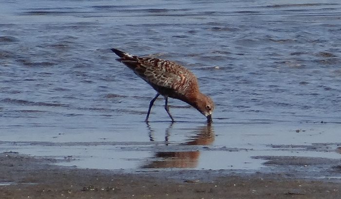
This Curlew Sandpiper was in full breeding plumage in Richard’s Bay, South Africa, and would have been about to leave for the breeding grounds on 15 April 2016. Its route to the tundra might have taken it through the Ukraine. The photograph is by Richard Johnstone, and is curated in BirdPix, as record 25818
Not all Curlew Sandpipers migrating from their non-breeding grounds in Africa to the breeding areas in Siberia follow the same route. But the total number of really good wetlands for refuelling is small.
One of the best is the Sivash, in the western edge of the Sea of Azov, which in turn is in the northeastern part of the Black Sea, in the disputed territory of the Crimean Peninsula:
Location of the Sivash, in Ukraine (when this study was done). The two wetlands marked SC-22 and SE-41 were the main ringing sites used by researchers from the Azov-Black Sea Ornithological Station, headquartered in Melitopol, Ukraine. This map is from Diadicheva & Khomenko 2006)
Researchers at the Azov-Black Sea Ornithological Station estimate that around 66,000 Curlew Sandpipers refuel in the Sivash on northwards migration (and 160,000 on autumn migration). Most refueling sites for Curlew Sandpipers (and other waders on migration) are tidal. This results in extensive areas of mud and sand becoming available at every low tide for feeding. But the Black Sea is too small to have any tides at all, and this applies also to the Sea of Azov, and especially the Sivash.
So how come the Sivash a great refueling site? The answer is the wind. It is a complex area of shallow lagoons. As the wind blows in one direction, it pushes water along with it, and this results in some mudflats being exposed for a while. Then it blows in a different direction, and another set of mudflats are exposed. The refueling waders continuously redistribute themselves opportunistically to use the best areas under any one set of wind conditions.
In studies which started in 1974, it is known that northward passage of Curlew Sandpipers through the Sivash starts in mid-April. Peak migration is in the period 11-20 May, and it tapers off by the end of the month.
So in the next few weeks, Curlew Sandpipers, and many other birds, probably counted in millions, are going to migrate through the battle zones of the eastern half of Ukraine. It will be migration in a time of war. We simply have no idea of whether the habitats they will use have been impacted by military activity.
The Ukrainians based at the Azov-Black Sea Ornithological Station have done extensive bird ringing (see the map above for the main ringing sites). They have retrapped Curlew Sandpipers from other countries, and theirs have been retrapped elsewhere. This information is summarized in this map:
Long-distance recoveries and retraps of Curlew Sandpipers either ringed or recovered** in Ukraine. The lines on the map do not imply that the birds have taken this route! For almost all of these recoveries there was a trip to the breeding grounds in Siberia, or the non-breeding grounds in Africa between the ringing observation and the retrap/recovery observation. This map is from Diadicheva & Khomenko 2006). **In the terminology used in ringing, “recovery” means that it is the ring that was “recovered” and that the bird is dead! In “retraps”, the bird was caught again, its ring number was recorded, and the bird was let loose, alive!
From the Ukrainian perspective, their Curlew Sandpipers are linked with a remarkable number of countries: Norway, Finland, Poland, Swede, Germany, UK, France, Spain, Hungary, Italy, Bulgaria, Russia, Greece, Tunisia, Morocco, Senegal, Benin, Mali, Sudan, Chad, Namibia and South Africa – that is 22 countries that have shared individual Curlew Sandpipers with the Ukraine via bird rings. In reality, there are many more.
The media coverage of armed conflict and war rightly tends to focus on the humanitarian impacts. But it is important to grasp that war also has impacts on biodiversity. The land over which the war is fought is frequently degraded (think defoliants, bomb craters, soil compaction and chemical contamination from weapons such as tanks), so that important habitats are damaged and species loss accelerated. Conservation initiatives fall by the wayside. Research, and especially the type of research that provided the data used in this blog, stops. In some parts of the world, war leads to increases in wildlife poaching and human encroachment on protected areas. Sadly, the impacts of war on biodiversity are so widespread (and so poorly understood) that a subdiscipline of ecology known as “warfare ecology” has come into existence (see Machlis, G.E. & Hanson, T. 2008. Warfare ecology. BioScience 58: 729–736).
Recommended citation format: Underhill LG 2022. Migration in a time of war: through the battle zone. Biodiversity and Development Institute. Available Online at http://thebdi.org/2022/04/07/migration-in-a-time-of-war-through-the-battle-zone/
Find the Southern Caco in the FBIS database (Freshwater Biodiversity Information System) here.
Family Pyxicephalidae
Identification
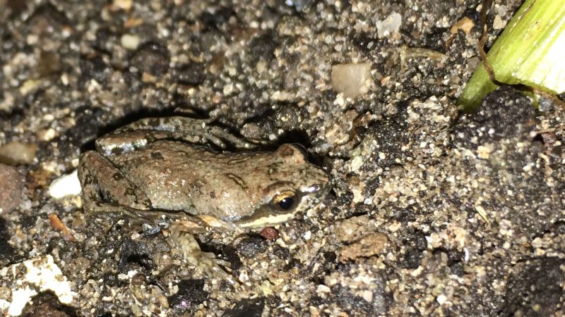
The Southern Caco is a small species that attains 18mm in length. It is a graceful frog with a narrow head and a wide body. The upper parts are pale brown with scattered dark markings. A broad paler band is sometimes present, running from the snout down the length of the back. A dark band extends from around the eye to the forearm, and there is a broad white band on the upper lip. The underside is smooth with numerous small black spots and brown markings.
Southern CacoCacosternum australis Nuwejaars Wetlands Special Management Area, Western Cape Photo by E. Brink
Habitat
The Southern Caco frequents temporary rain-filled pools in sandy coastal areas and in rocky places further inland.
Behaviour
Very little is known about the life history of C. australis. The advertisement call of this species has been likened to the sound of a bouncing marble. The ecology of the Southern Caco is likely similar to other Cacosternum species.
Status and Conservation
Data deficient. The Southern Caco was only described in 2013.
Distribution
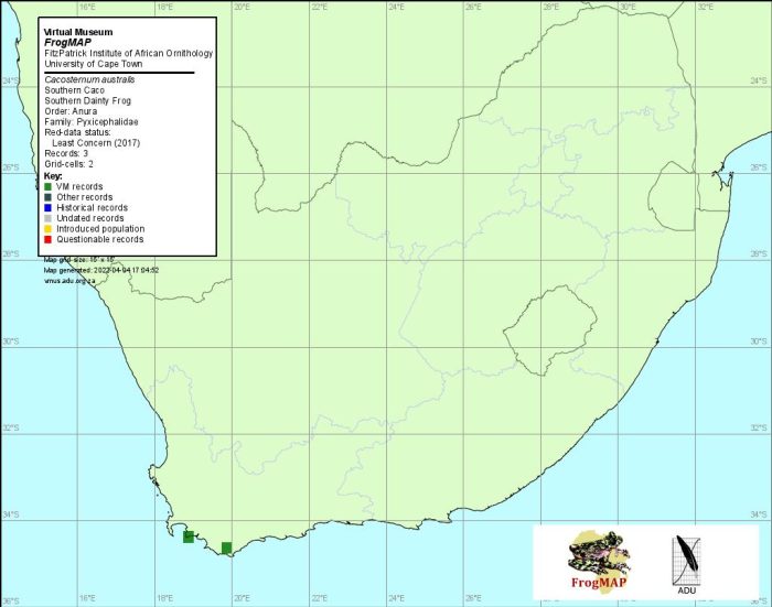
The Southern Caco C. australis is endemic to South Africa and is restricted to the southern Cape and Little Karoo.
Distribution of Cacosternum australis. Taken from the FrogMap database, April 2022.
Further Resources
The use of photographs by E. Brink and Jorrie Jordaan is acknowledged.
Southern CacoCacosternum australisChanning et al., 2013
Other Common Names: Suidelike Blikslanertjie (Afrikaans)
Recommended citation format: Tippett, RM. (2025). Southern Caco Cacosternum australis. Biodiversity and Development Institute, Cape Town. Available online at https://thebdi.org/2022/04/04/southern-caco-cacosternum-australis/
References:
Minter, LR; Burger, M; Harrison, JA; Braack, HH; Bishop, PJ; Kloepfer, D. (Editors). (2004). Atlas and Red Data Book of the Frogs of South Africa, Lesotho and Swaziland. Smithsonian Institution, Washington, and Avian Demography Unit, Cape Town.
Carruthers, V; du Preez, L. (2017). Frogs of southern Africa: A Complete Guide. Struik Nature, Cape Town.
Channing, A. (2001) Amphibians of Central and Southern Africa. Protea Book House, Pretoria
There are currently no photographs or maps available for this species.
Find Branch’s Rain Frog in the FBIS database (Freshwater Biodiversity Information System) here.
Family Brevicepitidae
Identification
Branch’s Rain Frog measures up to 41mm in length. This species is stout with short legs, large, bulging eyes and a pale coloured iris. The dorsal surface is yellowish-brown with large dark brown markings. It has a series of yellowish paravertebral patches down the back and a yellowish bar between the eyes. There are also numerous small white glandular warts on the skin, which are most prevalent along the sides. The facial mask is dark brown and extends from the eye to the armpit. The undersides are covered in tiny white asperities, and there is a translucent patch of skin in the belly region.
Branch’s Rain Frog is most similar to the Namaqua Rain Frog (Breviceps namaquensis), and both occur in the same general vicinity. Branch’s Rain Frog differs in the facial mask reaching to the armpit (extending only halfway to the armpit in B. namaquensis), and by the many small granules under the fourth finger (lacking in B. namaquensis).
Habitat
Branch’s Rain Frog is found on red sands with sparse vegetation in the Richtersveld Duneveld, Northern Cape.
Behaviour
Virtually nothing is known about this species. It is known from just a single specimen.
Status and Conservation
Data deficient. More information is required for this species.
Distribution
B. branchi is so far only known from the far Northern Cape near the Holgat river.
Further Resources
Branch’s Rain FrogBreviceps branchiChanning, 2012
Other Common Names: Branch se Blaasoppadda (Afrikaans)
Recommended citation format: Tippett, RM. (2025). Branch’s Rain Frog Breviceps branchi. BDI, Cape Town. Available online at http://thebdi.org/2022/04/04/branchs-rain-frog-breviceps-branchi/
References:
Carruthers, V; du Preez, L. (2017). Frogs of southern Africa: A Complete Guide. Struik Nature, Cape Town.
View the above photo record (by Jean-Paul Brouard) in FrogMAPhere.
Find the Power’s Long Reed Frog in the FBIS database (Freshwater Biodiversity Information System) here.
Family Hyperoliidae
POWER’S LONG REED FROG – Hyperolius poweri
Loveridge, 1938
Habitat
This species inhabits the Savanna and Grassland biomes. In South Africa it occurs at or near sea level in Coastal Bushveld-Grassland. It breeds in shallow coastal pans, vleis and inundated grassland with dense, emergent and/or littoral vegetation – in particular, the sedges Eleocharis limosa and Cyperus papyrus (Poynton 1964; Lambiris 1989a; Passmore and Carruthers 1995; pers. obs.). In Malawi it has been found in dense, emergent vegetation associated with marshes, ponds and streams in open and wooded country, and on the edge of forest, from the lakeshore at an altitude of 475 m, up to 2286 m on the Nyika Plateau (Stewart 1967; A. Turner pers. obs.). In Zimbabwe it has been found breeding in pans and flooded grassland (A. Turner pers. comm.).
Behaviour
Very little is known about the behavioural ecology of this species during the non-breeding season. Breeding takes place in the wet season (Stewart 1967). During the day, adults sit in exposed positions on emergent vegetation, parallel to the stem or leaf blade, but dive into the water when disturbed. In the afternoon, and at night, males call from elevated positions, near the tops of sedges and reeds, and frequently engage in territorial disputes (Wager 1965; Stewart 1967; Razetti and Msuya 2002; A. Turner pers. comm.).
Females deposit 60–292 eggs, in groups of 2–20, on submerged leaves or roots. Tadpoles leave the egg capsule about five days later (Wager 1965).
Predators include various birds, snakes, terrapins, spiders and other frogs, while prey consists mainly of flying insects (pers. obs.).
A major threat to H. acuticeps is habitat loss through the drainage of wetlands for agricultural and urban development. In several areas in KwaZulu-Natal, Eucalyptus plantations have lowered the water table to such a degree that many coastal pans have completely disappeared; as a result, the species’ range has been considerably diminished during the past c.15 years. With the exception of populations within nature reserves, the species is now encountered only rarely; in the past, it was much more common and widespread.
This species occurs in several established provincial reserves and protected areas and does not appear to require any further conservation action. However, because of recent declines, it is recommended that protected populations be monitored.
Hyperolius poweri– Umlalazi Nature Reserve, KwaZulu-Natal Photo by Ryan van Huysteen
Distribution
H.poweri occurs in a narrow band down the east coast. It ranges from southern Mozambique and down the length of the KwaZulu-Natal coast, extending marginally into the Eastern Cape.
Distribution of Hyperolius poweri. Taken from the FrogMAP database, April 2022.
Further Resources
Virtual Museum (FrogMAP > Search VM > By Scientific or Common Name)
More common names: Sharp-nosed Reed Frog, Long Reed Freog (Alternative English Names); Power se Skerpneusrietpadda (Afrikaans)
Recommended citation format for this species text:
Bishop PJ, Tippett RM. Power’s Long Reed Frog Hyperolius poweri. BDI, Cape Town. Available online at http://thebdi.org/2022/04/04/powers-long-reed-frog-hyperolius-poweri/
Recommended citation format:
This species text has been updated and expanded from the text in the 2004 frog atlas. The reference to the text and the book are as follows:
Bishop PJ 2004 Hyperolius acuticeps Sharp-nosed Reed Frog. In Minter LR et al 2004.
Minter LR, Burger M, Harrison JA, Braack HH, Bishop PJ, Kloepfer D (eds) 2004. Atlas and Red Data Book of the Frogs of South Africa, Lesotho and Swaziland. Smithsonian Institution, Washington, and Avian Demography Unit, Cape Town.
Hyperolius poweri – Trafalgar, KwaZulu-Natal Photo by Joan Young
There are currently no photographs or maps available for this species.
Find the Cederberg Ghost Frog in the FBIS database (Freshwater Biodiversity Information System) here.
Family Heleophrynidae
Identification
The upper parts of the Cedarberg Ghost Frog are light to dark olive with large, irregular maroon coloured blotches. There may be scattered whitish spots on the limbs and back. The back is granular and covered in flattened warts, each with a conical asperity. The eyes have a dark cross-like marking caused by the horizontal pupil.
The undersides are creamy white to yellowish and granular.
The sexes are similar but females are larger. During the breeding season males develop swollen forearms and spines on the chest and inner fingers.
Habitat
The Cedarberg Ghost Frog inhabits clear mountain streams in the Fynbos biome.
Behaviour
The Cedarberg Ghost Frog is often found motionless and well camouflaged among river-bed stones.
Status and Conservation
The Cedarberg Ghost Frog is not threatened. Most of its range falls within protected areas.
Distribution
The Cedarberg Ghost Frog is restricted to the Cedarberg Mountain range, to the north and west of the Breede and Berg Rivers.
Other Common Names: Sederberg-spookpadda (Afrikaans).
Recommended citation format: Tippett, RM. (2025). Cedarberg Ghost Frog Heleophryne depressa. Biodiversity and Development Institute, Cape Town. Available online at https://thebdi.org/2022/04/04/cederberg-ghost-frog-heleophryne-depressa/
References:
Minter, LR; Burger, M; Harrison, JA; Braack, HH; Bishop, PJ; Kloepfer, D. (Editors). (2004). Atlas and Red Data Book of the Frogs of South Africa, Lesotho and Swaziland. Smithsonian Institution, Washington, and Avian Demography Unit, Cape Town.
Carruthers, V; du Preez, L. (2017). Frogs of southern Africa: A Complete Guide. Struik Nature, Cape Town.
Channing, A. (2001) Amphibians of Central and Southern Africa. Protea Book House, Pretoria
Claus, B; Claus, R. (2002). Common Amphibians and Reptiles of Botswana. Gamsberg Macmillan, Windhoek.
There is currently no photograph available for this species.
Find the Moonlight Mountain Toadlet in the FBIS database (Freshwater Biodiversity Information System) here.
Family Bufonidae
Identification
The Moonlight Mountain Toadlet is a small Bufonid that attains a maximum size of 23.5mm. It has a toad-like appearance, but unlike true toads, it has soft, smooth skin with blister-like ridges and warts, and the body is somewhat elongated.
The upper parts are greyish-brown with an orange vertebral stripe surrounded by pale brown. A number of dorsal spots are also present, each with incomplete black rings with a thin white margin. The parotid glands are reddish-brown and elongated. There is a pale whitish area that extends from around the eye to the lip and down to the upper arm. The tympanum is not visible. The underside is dark with scattered white spots.
Habitat
The Moonlight Mountain Toadlet inhabits pristine mountain fynbos. It is known only from Akkedis Mountain, the Kleinrivier Mountains, and Kogelberg, Western Cape.
Behaviour
Not much is known of the life history of C. selenophos. The behaviour is likely to be similar to that of other Capensibufo species.
Status and Conservation
Unknown and data deficient. Capensibufo selenophos is likely to be threatened due to its restricted distribution.
Distribution
The Moonlight Mountain Toadlet is endemic to South Africa and is confined to a few mountain ranges in the Western Cape.
No maps are available for this species.
Further Resources
Moonlight Mountain ToadletCapensibufo selenophos Channing et al., 2017
Other Common Names: Maanskynbergskurwepadda (Afrikaans)
Recommended citation format: Tippett, RM. (2025). Moonlight Mountain Toadlet Capensibufo selenophos. Biodiversity and Development Institute, Cape Town. Available online at https://thebdi.org/2022/04/04/moonlight-mountain-toadlet-capensibufo-selenophos/
References:
Minter, LR; Burger, M; Harrison, JA; Braack, HH; Bishop, PJ; Kloepfer, D. (Editors). (2004). Atlas and Red Data Book of the Frogs of South Africa, Lesotho and Swaziland. Smithsonian Institution, Washington, and Avian Demography Unit, Cape Town.
Carruthers, V; du Preez, L. (2017). Frogs of southern Africa: A Complete Guide. Struik Nature, Cape Town.
Channing, A. (2001) Amphibians of Central and Southern Africa. Protea Book House, Pretoria
There is currently no photograph available for this species.
Find the Landdroskop Mountain Toadlet in the FBIS database (Freshwater Biodiversity Information System) here.
Family Bufonidae
Identification
The Landdroskop Mountain Toadlet is a small Bufonid that attains a maximum size of 26mm. It has a distinct toad-like appearance, but unlike true toads, it has smooth skin with blister-like ridges and warts, and the body is somewhat elongated.
The dorsal surface is variably marked in grey and light brown with numerous blackish flecks. The vertebral band is broad, and the warts are dark brown with incomplete black edges. The parotid glands are red-brown and conspicuous. The tympanum is absent, and the underside is granular.
Habitat
The Landdroskop Mountain Toadlet inhabits pristine mountain fynbos in the Hawequas, Riviersonderend and Hottentots Holland Mountains.
Behaviour
Very little is known about the life history of C. magistratus. The behaviour is probably similar to that of other Capensibufo species.
Status and Conservation
Unknown and data deficient. Capensibufo magistratus is likely to be threatened due to its restricted distribution.
Distribution
The Landdroskop Mountain Toadlet is endemic to South Africa and is confined to a few mountain ranges in the Western Cape.
No maps are available for this species.
Further Resources
Landdroskop Mountain Toadlet Capensibufo magistratus Channing et al., 2017
Other Common Names: Landdroskop-bergskurwepadda (Afrikaans)
Recommended citation format: Tippett, RM. (2025). Landdroskop Mountain ToadletCapensibufo magistratus . Biodiversity and Development Institute, Cape Town. Available online at https://thebdi.org/2022/04/04/landdroskop-mountain-toadlet-capensibufo-magistratus/
References:
Minter, LR; Burger, M; Harrison, JA; Braack, HH; Bishop, PJ; Kloepfer, D. (Editors). (2004). Atlas and Red Data Book of the Frogs of South Africa, Lesotho and Swaziland. Smithsonian Institution, Washington, and Avian Demography Unit, Cape Town.
Carruthers, V; du Preez, L. (2017). Frogs of southern Africa: A Complete Guide. Struik Nature, Cape Town.
Channing, A. (2001) Amphibians of Central and Southern Africa. Protea Book House, Pretoria
There are currently no photographs available for this species.
Find the Deception Peak Mountain Toadlet in the FBIS database (Freshwater Biodiversity Information System) here.
Family Bufonidae
Identification
The Deception Peak Mountain Toadlet is a small Bufonid that attains a maximum size of 38mm. It has a toad-like appearance, but unlike true toads, it has smooth skin with blister-like ridges and warts, and the body is somewhat elongated.
The dorsal surface is dark reddish-brown with a thin white vertebral stripe surrounded by a broad pale-brown band. The parotid glands are dark orange and conspicuous. There is a pale whitish area that extends from around the eye to the lip and down to the upper arm. The tympanum is visible and is smaller than the eye. The underside is pale and plain to lightly speckled.
Habitat
The Deception Peak Mountain Toadlet inhabits pristine mountain fynbos along the Du Toitskloof Mountains.
Behaviour
Very little is known about the life history of the Deception Peak Mountain Toadlet. It’s behaviour is probably similar to that of other Capensibufo species.
Status and Conservation
Unknown and data deficient. Capensibufo deceptus is likely to be threatened due to its restricted distribution.
Distribution
The Deception Peak Mountain Toadlet is endemic to South Africa and is confined to the Du Toitskloof Mountains, Western Cape. It may also occur in the Kogelberg Nature Reserve.
No maps are currently available for this species.
Further Resources
Deception Peak Mountain ToadletCapensibufo deceptus Channing et al., 2017
Other Common Names: Du Toit se bergskurwepadda (Afrikaans)
Recommended citation format: Tippett, RM. (2025). Deception Peak Mountain Toadlet Capensibufo deceptus. Biodiversity and Development Institute, Cape Town. Available online at https://thebdi.org/2022/04/04/deception-peak-mountain-toadlet-capensibufo-deceptus/
References:
Minter, LR; Burger, M; Harrison, JA; Braack, HH; Bishop, PJ; Kloepfer, D. (Editors). (2004). Atlas and Red Data Book of the Frogs of South Africa, Lesotho and Swaziland. Smithsonian Institution, Washington, and Avian Demography Unit, Cape Town.
Carruthers, V; du Preez, L. (2017). Frogs of southern Africa: A Complete Guide. Struik Nature, Cape Town.
Channing, A. (2001) Amphibians of Central and Southern Africa. Protea Book House, Pretoria
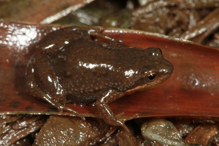
Find the Hogsback Caco in the FBIS database (Freshwater Biodiversity Information System) here.
Family Pyxicephalidae
Identification
The Hogsback Caco is a small species that reaches a maximum size of 15.6mm. The body is slender and widest in the belly region. The limbs are relatively long and slender. The upperparts are grey to brown or green, often with small, indistinct, pale blotches, and the skin is smooth. A pale vertebral line is sometimes also visible. The undersides are smooth and whiteish with fine mottling.
Hogsback CacoCacosternum thorini Hogsback Nature Reserve, Eastern Cape Photo by Luke Kemp
Habitat
The Hogsback Cacoinhabits montane grasslands where it frequents wetlands with well-vegetated pools.
Behaviour
Little is known about the life history of C. thorini. Its habits are expected to be similar to that of others in the genus. The advertisement call of this species consists of chirps and creaks given from concealed positions in damp grass.
Status and Conservation
Data deficient. Very little is known about the Hogsback Caco as it was only described in 2014.
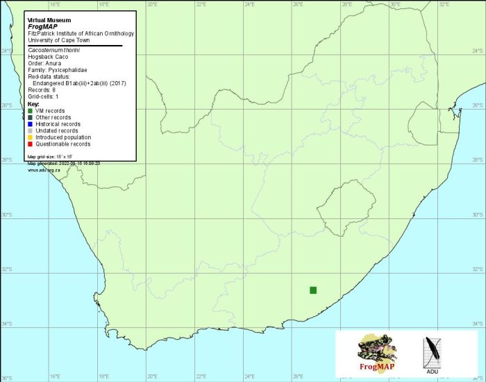
Distribution
The Hogsback Caco is endemic to South Africa and is restricted to the Hogsback and Amatola Mountains in the Eastern Cape.
Distribution of Cacosternum thorini. Taken from the FrogMap database, April 2022.
Further Resources
The use of photographs by Luke Kemp is acknowledged.
Hogsback CacoCacosternum thoriniConradie, 2014
Other Common Names: Hogsback-Blikslanertjie (Afrikaans)
Recommended citation format: Tippett, RM. (2025). Hogsback CacoCacosternum thorini. Biodiversity and Development Institute, Cape Town. Available online at https://thebdi.org/2022/04/04/hogsback-caco-cacosternum-thorini/
References:
Minter, LR; Burger, M; Harrison, JA; Braack, HH; Bishop, PJ; Kloepfer, D. (Editors). (2004). Atlas and Red Data Book of the Frogs of South Africa, Lesotho and Swaziland. Smithsonian Institution, Washington, and Avian Demography Unit, Cape Town.
Carruthers, V; du Preez, L. (2017). Frogs of southern Africa: A Complete Guide. Struik Nature, Cape Town.
Channing, A. (2001) Amphibians of Central and Southern Africa. Protea Book House, Pretoria