
Cover photo by Basil Boer.
Find the Masai Sprite in the FBIS database (Freshwater Biodiversity Information System) here.
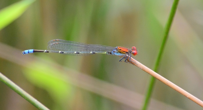
Family Coenagrionidae
Identification

Mkuze Game Reserve, KwaZulu-Natal
Photo by Ryan Tippett
Small size
Length up to 38mm; Wingspan reaches 45mm
The Masai Sprite is similar to the other ‘red’ sprites, but most resembles Pseudagrion sjoestedti (Variable Sprite) and Pseudagrion vaalense (Vaal Sprite).
Males are characterised by their largely red head and thorax, including red postocular spots. The lower thorax is pale pruinose blue, while the dark abdomen ends with a bright blue terminal segment.
Females are drab brown and best recognised by their association with the males.
Click here for more details on identification.

Selinda, Botswana
Photo by Ryan Tippett
Habitat
The Masai Sprite is found mostly at still-water habitats such as pans, dams, ponds, lakes and slow flowing parts of rivers and streams. Masai Sprites prefer well vegetated parts of water bodies, however they can also be found at water with bare gravelly or sandy banks provided there is at least some aquatic vegetation.

Photo by Ryan Tippett
Behaviour
The Masai Sprite perches on waterlilies and other emergent plants and twigs close to the water surface. It sometimes also sits on rocks or exposed sand at the waters edge. Flies low over the water when disturbed, hunting or changing perches. Females can be found near the males, but are frequently found away from the water in the surrounding bushes or woodlands.
The Masai Sprite has been recorded throughout the year at some sites, but is most active from September to April. See Phenology below.

Carnarvon district, Northern Cape
Photo by Ryan Tippett
Conservation and Status
The Masai Sprite is listed as of Least Concern in the IUCN Red List of Threatened Species. Pseudagrion massaicum is an abundant and widespread species that has widely benefited from the use of man-made impoundments. It can be found in somewhat degraded habitats, including sewage treatment ponds and areas with alien plants.

Muzi Pan, KwaZulu-Natal
Photo by Ryan Tippett
Distribution
The Masai Sprite is widespread across sub-Saharan Africa. It has been recorded from all provinces in South Africa and is likely to occur almost anywhere but is less numerous in arid regions.
Below is a map showing the distribution of records for Masai Sprite in the OdonataMAP database as at February 2020.
Below is a map showing the distribution of records for Masai Sprite in the OdonataMAP database as of December 2024.
The next map below is an imputed map, produced by an interpolation algorithm, which attempts to generate a full distribution map from the partial information in the map above. This map will be improved by the submission of records to the OdonataMAP section of the Virtual Museum.
Ultimately, we will produce a series of maps for all the odonata species in the region. The current algorithm is a new algorithm. The objective is mainly to produce “smoothed” maps that could go into a field guide for odonata. This basic version of the algorithm (as mapped above) does not make use of “explanatory variables” (e.g. altitude, terrain roughness, presence of freshwater — we will be producing maps that take these variables into account soon). Currently, it only makes use of the OdonataMAP records for the species being mapped, as well as all the other records of all other species. The basic maps are “optimistic” and will generally show ranges to be larger than what they probably are.
These maps use the data in the OdonataMAP section of the Virtual Museum, and also the database assembled by the previous JRS funded project, which was led by Professor Michael Samways and Dr KD Dijkstra.
Phenology

Montagu, Western Cape
Photo by Ryan Tippett
Further Resources
The use of photographs by Basil Boer is acknowledged. All other photographs by Ryan Tippett.
Masai Sprite Pseudagrion massaicum Sjöstedt, 1909
Other common names: Masaigesie (Afrikaans)
Recommended citation format: Loftie-Eaton M; Navarro R; Tippett RM; Underhill L. 2025. Masai Sprite Pseudagrion massaicum. Biodiversity and Development Institute. Available online at https://thebdi.org/2020/03/04/masai-sprite-pseudagrion-massaicum/
References: Tarboton, M; Tarboton, W. (2019). A Guide to the Dragonflies & Damselflies of South Africa. Struik Nature.
Samways, MJ. (2008). Dragonflies and Damselflies of South Africa. Pensoft
Samways, MJ. (2016). Manual of Freshwater Assessment for South Africa: Dragonfly Biotic Index. Suricata 2. South African National Biodiversity Institute, Pretoria
Martens, A; Suhling, F. (2007). Dragonflies and Damselflies of Namibia. Gamsberg Macmillan.
Amakhosi Game Reserve, KwaZulu-Natal
Photo by Ryan Tippett