

Cover photo by Gary Brown.
Find the Brown Duskhawker in the FBIS database (Freshwater Biodiversity Information System) here.
Family Aeshnidae
Identification

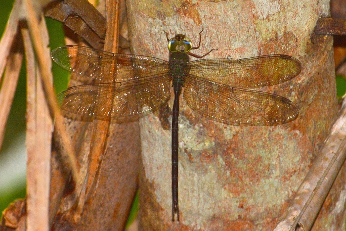
Chongwe, Zambia
Main photo by Norman Barrett
Inset photo by Gary Brown
Very large
Length up to 77mm; Wingspan attains 114mm.
The sexes are very similar but males are slightly brighter, have a 4-celled anal triangle and a narrower waist.
The Brown Duskhawker is most likely to be confused with the Little Duskhawker (Gynacantha manderica) and the Eastern Duskhawker (Gynacantha usambarica). Gynacantha villosa can be told apart by the double cell row between the R2 and R3 veins in the forewings. The other two species have only a single row of cells. The Brown Duskhawker is also unique among Southern African species in having a black ring around the metastigma on the sides of the thorax, and in males, a four-celled anal triangle.
Click here for more details on identification of the Brown Duskhawker.

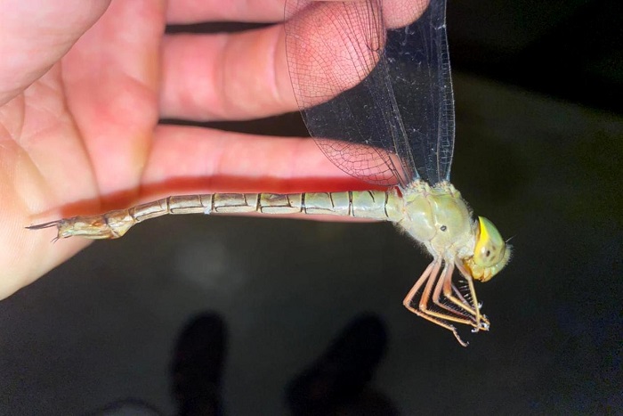
Phalaborwa, Limpopo
Photo by Coen Van den Berg
Habitat
The Brown Duskhawker occupies coastal and especially swamp forests along the northern KwaZulu-Natal coast. It is found in the vicinity of streams and pools, typically in deep shade surrounded by dense vegetation. Further inland, the Brown Duskhawker inhabits riverine forests fringing large savanna rivers.

Near Kosi Bay, KwaZulu-Natal
Photo by Ryan Tippett
Behaviour
The Brown Duskhawker is elusive, crepuscular, and seldom seen. It rests by day in dark, shaded undergrowth. It hangs vertically from a perch when at rest. The Brown Duskhawker is most active at dawn and dusk when it emerges to hunt over pools, streams, and clearings. The flight is fast and powerful. The Brown Duskhawker is sometimes attracted to lights in the early evening.
Status and Conservation
The Brown Duskhawker is uncommon to rare and localised in South Africa. It is listed as Vulnerable in the IUCN Red List of Threatened Species. Gynacantha villosa is generally intolerant of habitat degradation and is mostly found at undisturbed sites.
Kosi Bay, iSimangaliso Wetland Park, KwaZulu-Natal
Photo by Ryan Tippett
Distribution
The Brown Duskhawker is found in East and Southern Africa. Its range extends from Ethiopia in the north down through Uganda, Kenya, and Tanzania to Zambia, Malawi, Mozambique, Zimbabwe, and marginally into South Africa. In South Africa, the Brown Duskhawker is only found in coastal north-eastern KwaZulu-Natal and along some of the larger east-flowing rivers in the Limpopo and Mpumalanga lowveld.
Below is a map showing the distribution of records for Brown Duskhawker in the OdonataMAP database as at February 2020.

Below is a map showing the distribution of records for Brown Duskhawker in the OdonataMAP database as of December 2024.
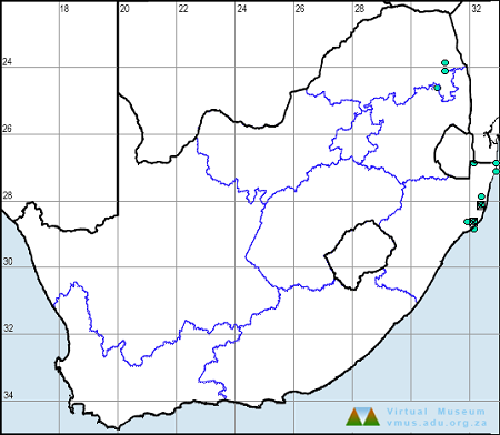
The next map below is an imputed map, produced by an interpolation algorithm, which attempts to generate a full distribution map from the partial information in the map above. This map will be improved by the submission of records to the OdonataMAP section of the Virtual Museum.


Ultimately, we will produce a series of maps for all the odonata species in the region. The current algorithm is a new algorithm. The objective is mainly to produce “smoothed” maps that could go into a field guide for odonata. This basic version of the algorithm (as mapped above) does not make use of “explanatory variables” (e.g. altitude, terrain roughness, presence of freshwater — we will be producing maps that take these variables into account soon). Currently, it only makes use of the OdonataMAP records for the species being mapped, as well as all the other records of all other species. The basic maps are “optimistic” and will generally show ranges to be larger than what they probably are.
These maps use the data in the OdonataMAP section of the Virtual Museum, and also the database assembled by the previous JRS funded project, which was led by Professor Michael Samways and Dr KD Dijkstra.
Phenology

Klaserie Game Reserve, Limpopo
Photo by Quintin Paul Josop
Further Resources
The use of photographs by Coen Van den Berg, Gary Brown, Norman Barrett, and Quintin Paul Josop is acknowledged. All other photographs by Ryan Tippett.
Brown Duskhawker Gynacantha villosa Grünberg, 1902
Other Common Names: Bruinskemerventer (Afrikaans).
Recommended citation format: Loftie-Eaton M; Navarro R; Tippett RM; Underhill L. 2025. Brown Duskhawker Gynacantha villosa. Biodiversity and Development Institute. Available online at https://thebdi.org/2020/05/18/brown-duskhawker-gynacantha-villosa/
References: Tarboton, M; Tarboton, W. (2019). A Guide to the Dragonflies & Damselflies of South Africa. Struik Nature.
Samways, MJ. (2008). Dragonflies and Damselflies of South Africa. Pensoft
Samways, MJ. (2016). Manual of Freshwater Assessment for South Africa: Dragonfly Biotic Index.Suricata 2. South African National Biodiversity Institute, Pretoria