
The pentad is the spatial unit used by the African Bird Atlas Project. A pentad is five minutes of latitude from north to south, and five minutes of longitude from east to west.
At the Equator, pentads are “square”. The dimensions of a pentad there are 9.2 km north to south and the same east to west. They are essentially square, with a minute distortion caused by the curvature of the Earth, which at this scale can be ignored.
But as one travels north or south away from the Equator, the lines of longitude get closer together, because of the way they are plotted on the spherical Earth. By the time you get to the southern end of Africa, at 34 degrees south, the east-west length of a pentad is 7.7 km. And it is the same at the far north of Africa. So the whole of Africa is lucky; we can do biodiversity atlas projects using a geographical grid, i.e. with degrees and minutes. Even though the ends of Africa are a third of the way towards the South Pole and the North Pole, the “shrinkage” of the pentads from being squares is only 16%. Over most of Africa, it is less than this, so the pentads are “almost squares”. Look at this graphic:

But once you get into the latitudes of northern Europe, pentads don’t work. For example, in Oslo, almost 60 degrees north, a pentad would still be 9.2 km north to south, but only half that, 4.6 km east to west. In other words, pentads are no longer even approximately “square”, they become narrow rectangles. Farther north, they become even narrower! So in Europe, atlas projects use a grid measured in kilometres.
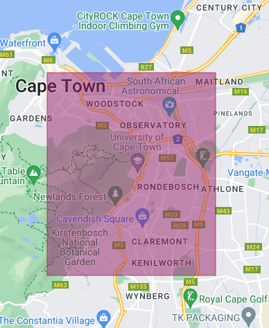
For the African Bird Atlas Project, we have given the pentads code names determined by the coordinates of the northwest corner. For those who find compass directions a challenge, that is the top-left corner. Pentads were first developed in 2007, for South Africa, Lesotho and Eswatini, the three countries in which the African Bird Atlas Project started. These countries are all in the southern hemisphere, and the degrees for both the longitudes and the latitudes have two digits, so it was agreed that the pattern for the code names for the pentads would become things like 3355_1825. Abstractly, the pattern is DDMM_ddmm where DD is the degrees south, MM is the minutes south (always a multiple of five), dd is the degrees east and mm is the minutes east (also always a multiple of five). So the Cape Town pentad in the graphic above, 3355_1825, is the pentad which had northwest corner 33 degrees and 55 minutes south, 18 degrees and 25 minutes east.
To find the southwest (bottom right) corner of a pentad, add five to both sets of minutes. Bear in mind that there is a silly complexity. Minutes are not decimals of degrees; some clown decided that there would be 60 minutes in one degree! So for pentad 3355_1825, 33 degrees and 55+5 minutes, should be 33 degrees 60 minutes, but this is known to everyone as 34 degrees 00 minutes. The 18 degrees 25+5 minutes is simply 18 degrees 30 minutes. So the southwest (bottom right) corner of pentad 3355_1825 is 34 degrees south, 18 degrees and 30 minutes east.
The pattern DDMM_ddmm worked fine in the south and the east. But there was a problem when the atlas project expanded to the northern hemisphere. For a variety of reasons, the strategy was to use an “b” in the middle, in place of “_” for pentads in the north and west (as for example in Senegal), and a “c” for pentads in the north and east (as in Nigeria, and the part of Kenya north of the Equator).

Most of the early bird atlases in southern Africa used a “quarter degree grid”, which is 15 minutes of latitude by 15 minutes of longitude, in place of the five minute grid used in the African Bird Atlas Project. This means that there are nine pentads (three rows and three columns) in a quarter degree grid cell. Yet another clown devised the system for naming quarter degree grid cells. This person should have been allowed to design only one more thing … a tombstone. Here is a blog which makes an attempt to explain the naming system: quarter degree grid cells made simple.