
Cover photo by Rob Dickinson.
Find this species in the FBIS database (Freshwater Biodiversity Information System) here.
Family Libellulidae
Identification
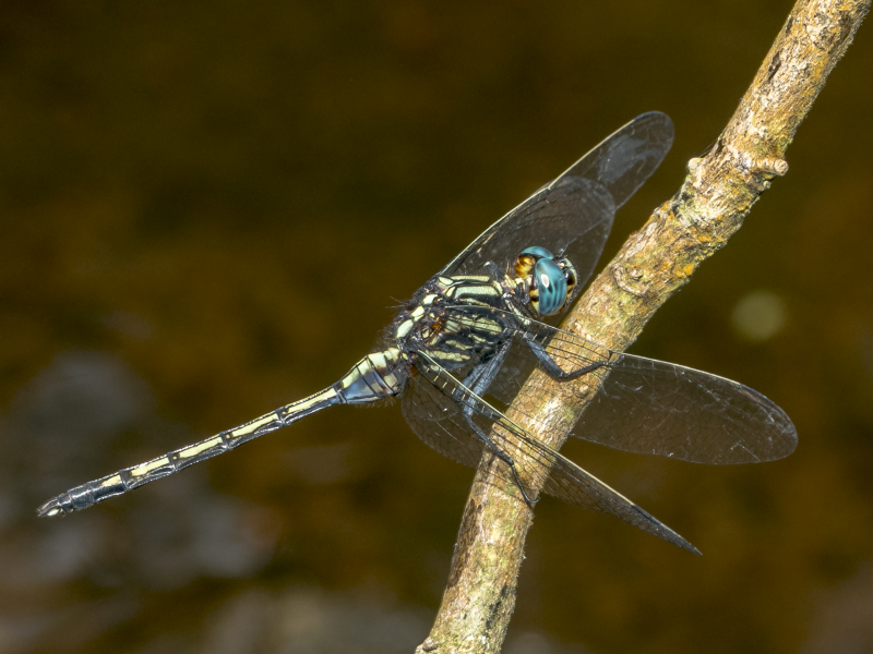
Near Tshipise, Limpopo
Photo by John Wilkinson
Medium Sized
Length up to 44mm; Wingspan attains 71mm.
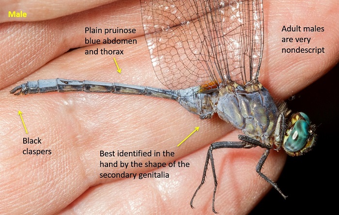
The Guinea Skimmer is most similar to Orthetrum machadoi (Highland Skimmer). The two species were up until recently thought to be conspecific. Mature males of the two can only be definitively identified by the respective shapes of the secondary genitalia.
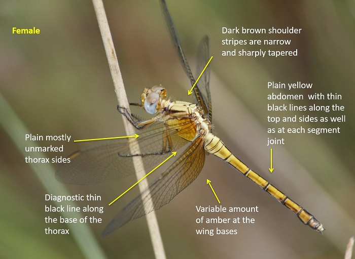
Immature males and females of Orthetrum guineense can be recognised by the mostly unmarked thorax sides, the fine black markings on the abdomen and by the fine black line along the base of the thorax (diagnostic).
Click here for more details on identification.
Mphaphuli Nature Reserve, Limpopo
Photo by John Wilkinson
Habitat
The Guinea Skimmer inhabits the marshy fringes of flowing streams and rivers. It is usually found in hilly savanna regions above 700m above sea level.
Behaviour
The Guinea Skimmer is usually found close to water. It perches on rocks or overhanging vegetation. The Guinea Skimmer hunts from a perch to which it often returns.
Recorded to be on the wing from September through to June.
Status and Conservation
The Guinea Skimmer is uncommon and localised in South Africa. It is listed as of Least Concern in the IUCN Red List of Threatened Species.
Distribution
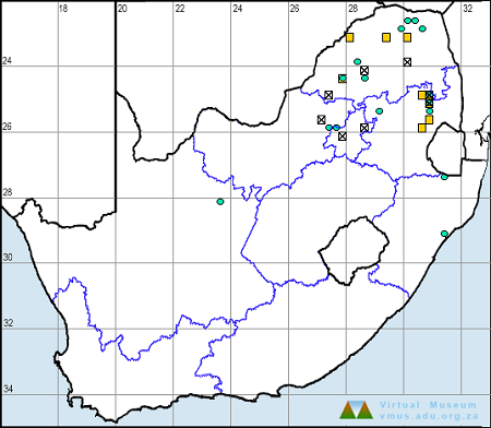
The Guinea Skimmer is patchily distributed over much of Sub-Saharan Africa. It occurs in West and Central Africa, and from East Africa to the north-eastern parts of southern Africa.
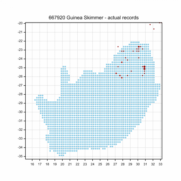
Orthetrum guineense is scarce and sparsely distributed in South Africa where it is restricted to the upland savanna regions of the northern provinces.
Below is a map showing the distribution of records for Guinea Skimmer in the OdonataMAP database as at February 2020.
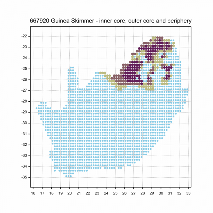
Below is a map showing the distribution of records for Guinea Skimmer in the OdonataMAP database as of December 2024.
The next map below is an imputed map, produced by an interpolation algorithm, which attempts to generate a full distribution map from the partial information in the map above. This map will be improved by the submission of records to the OdonataMAP section of the Virtual Museum.
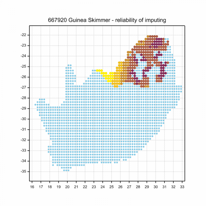
Ultimately, we will produce a series of maps for all the odonata species in the region. The current algorithm is a new algorithm. The objective is mainly to produce “smoothed” maps that could go into a field guide for odonata. This basic version of the algorithm (as mapped above) does not make use of “explanatory variables” (e.g. altitude, terrain roughness, presence of freshwater — we will be producing maps that take these variables into account soon). Currently, it only makes use of the OdonataMAP records for the species being mapped, as well as all the other records of all other species. The basic maps are “optimistic” and will generally show ranges to be larger than what they probably are.
These maps use the data in the OdonataMAP section of the Virtual Museum, and also the database assembled by the previous JRS funded project, which was led by Professor Michael Samways and Dr KD Dijkstra.
Further Resources
The use of photographs by John Wilkinson and Rob Dickinson is acknowledged.
Guinea Skimmer Orthetrum guineense Ris, 1910
Other common names: Guinese Skepper (Afrikaans)
Recommended citation format: Loftie-Eaton M; Navarro R; Tippett RM; Underhill L. 2025. Guinea Skimmer Orthetrum guineense. Biodiversity and Development Institute. Available online at https://thebdi.org/2020/05/21/guinea-skimmer-orthetrum-guineense/
References: Tarboton, M; Tarboton, W. (2019). A Guide to the Dragonflies & Damselflies of South Africa. Struik Nature.
Samways, MJ. (2008). Dragonflies and Damselflies of South Africa. Pensoft
Samways, MJ. (2016). Manual of Freshwater Assessment for South Africa: Dragonfly Biotic Index. Suricata 2. South African National Biodiversity Institute, Pretoria
Martens, A; Suhling, F. (2007). Dragonflies and Damselflies of Namibia. Gamsberg Macmillan.