

In October 2019, the piece of the Black River between the N1 and Section Street in the City of Cape Town looked like this:
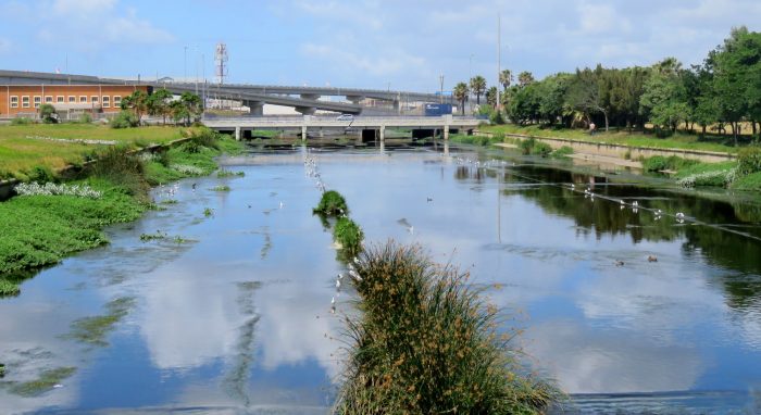
It was described in a 2019 blog as a novel ecosystem. A place that has been changed out of all recognition, but where biodiversity is doing its best to recover what is feasible. The 2019 blog had photos of a variety of waterbird species breeding, and it listed an interesting diversity of species, including Pied Kingfisher. The old blog is worth a read.
In July 2024, this piece of the river looked like this. Every scrap of vegetation has gone. It is a plantless and sterile habitat. For all practical purposes, it has been transformed into a desert. A wet desert, but nonetheless a desert!

But why? The photo below explains …

… the sole purpose of this “river” is now to act as a mega stormwater drain.The area of hard surface (roads, roofs and paving) in the catchment of this river is ever increasing. None of the rain that falls on these surfaces can soak in. All of it instantly becomes reclassified as “stormwater”. It drains off our roofs into our gutters, down the drainpipes, and out into the street where it joins the rain that has fallen on the roads, along the gutters in the streets, down the stormwater drains, and into the underground pipes that discharge the water into the nearest river. It needs to be drained away as fast as possible, otherwise there are floods. It all rapidly ends up in rivers, like this. No impediments to flow can be countenanced! As fast as possible, the stormwater must reach the sea.

The stormwater from a vast part of the suburbs of Cape Town drains to the sea along this section of river. The green line is the boundary of the catchment; the total area is 214 square kilometres. In the northeast, the Elsieskraal River starts in the Tygerberg Hills, drains most of the Northern Suburbs and a large fraction of the Cape Flats, as far east as Cape Town International Airport. All the suburbs on the western edge of Table Mountain (eg Newlands, Rondebosch) drain into the Black River via the Liesbeek River.

The same view at 15h00 on 9 July 2024! There was a cloudburst over the 214-square kilometre catchment for several hours just before this photo was taken! The stormwater drain is being challenged to its limits! The water level is getting close to the N1 bridge, the low bridge for the main highway of the N1 between Cape Town and Paarl. The elevated bridges are for the N1 to M5 interchange,
… and below is the view from the other side of the Section Street bridge towards the ocean, a kilometre away, 15h00, 9 July 2024.

… and on a smaller scale …
This photograph was in the 2019 blog. This was part of the east bank of the river, taken from the Section Street bridge. This “garden” has an abstract beauty of its own, a un-designed kaleidoscope of colours. It was attractive to a pair of Levaillant’s Cisticolas. Spot them on the reeds in the foreground.

… but the imperatives of getting stormwater to the sea as fast as possible resulted in the transformation below…

Every scrap of vegetation within the river, or hanging over the edge, has gone!

The same view, 15h00 on 9 July 2024. The stormwater drain was just big enough. If any of that vegetation had remained, there would have been a flood!
… but some birds persist, against all the odds …
In spite of the transformation back to concrete, there were a few birds making a living on this section of the Black River.


Even after the storm of 9 July 2024, there were birds around:


… so …
… so the City’s obligation to prevent floods overrides all other considerations. For a very long time the fundamental orientation of city planners, everywhere, has been to get rid of stormwater as rapidly as possible. What can be done to change this? The trick is to slow the flow. Can we find ways of storing the stormwater for a while, and then letting it drain steadily into the rivers? The total volume of water is the same, but it flows over a longer period, and therefore not so fiercely.
The strategy being used is to build flood detention dams. These come in multiple forms, but the main objective is the same. Hold the water back, and let it leave more slowly then it arrives.

Useful background reading
Rivers and wetlands of Cape Town: caring for our rich aquatic heritage.