

View the above photo record (by Desire Darling) in OdonataMAP here.
Find the Makabusi Sprite in the FBIS database (Freshwater Biodiversity Information System) here.
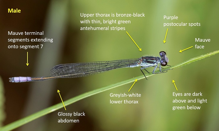
Family Coenagrionidae
Pseudagrion makabusiense – MAKABUSI SPRITE
Identification
Small size
Length reaches 36mm; Wingspan up to 41mm.
Unmistakeable and unlike any other damselfly in the region.
The mauve colouration on the terminal segments, postocular spots and on the face is diagnostic.
Females are yellowish to pale brown and similar to those of many other sprite species. Best identified by their association with the males.
Click here for more details on identification.
Mpumalanga
Photo by Desire Darling
Habitat
Inhabits streams and rivers in hilly savanna regions. Favours sites with tall grasses, sedge and reeds along the banks.
Behaviour
Perches on grass or reed stems, low down near the water. A rather inconspicuous species.
Most active from September to May (see Phenology below).
Status and Conservation
Common but very localised in South Africa. Listed as Vulnerable in the IUCN Red List of Threatened Species.
Distribution
The range of the Makabusi Sprite extends from South Africa (Limpopo, Gauteng and North-West provinces), up through Zimbabwe to northern Zambia. Also occurs marginally in southern DRC, eastern Angola and Mozambique.
Below is a map showing the distribution of records for Makabusi Sprite in the OdonataMAP database as at February 2020.
The next map below is an imputed map, produced by an interpolation algorithm, which attempts to generate a full distribution map from the partial information in the map above. This map will be improved by the submission of records to the OdonataMAP section of the Virtual Museum.
Ultimately, we will produce a series of maps for all the odonata species in the region. The current algorithm is a new algorithm. The objective is mainly to produce “smoothed” maps that could go into a field guide for odonata. This basic version of the algorithm (as mapped above) does not make use of “explanatory variables” (e.g. altitude, terrain roughness, presence of freshwater — we will be producing maps that take these variables into account soon). Currently, it only makes use of the OdonataMAP records for the species being mapped, as well as all the other records of all other species. The basic maps are “optimistic” and will generally show ranges to be larger than what they probably are.
These maps use the data in the OdonataMAP section of the Virtual Museum, and also the database assembled by the previous JRS funded project, which was led by Professor Michael Samways and Dr KD Dijkstra.