

Cover photo by Wil Leurs.
Find the Great Hooktail in the FBIS database (Freshwater Biodiversity Information System) here.
Family Gomphidae
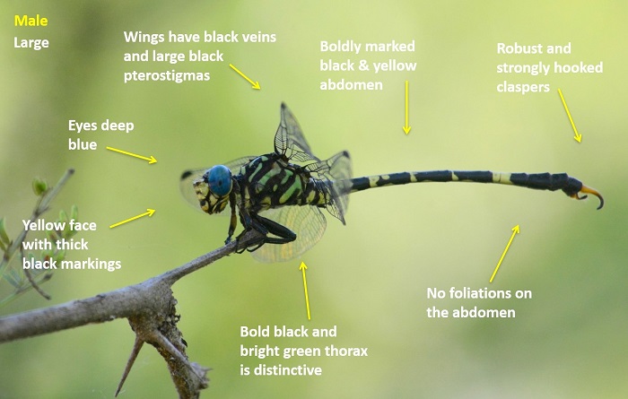
Identification
Pongola River, KwaZulu-Natal
Photo by Ryan Tippett
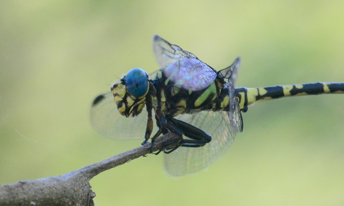
Large size
Length up to 58mm.
The Great Hooktail is a large and striking species. The combination of its large size, distinctive colouration and lack of foliations on the abdomen render this species unmistakable. Females, however, may be mistaken for those of the Zambezi Siphontail (Neurogompohus zambeziensis), but are more robustly built and with different thorax markings.
The sexes are similar but females lack the strongly hooked claspers of the male. Females are slightly duller, having a yellow-green and black thorax, rather than the bright green and black of the males.
Click here for more details on identification of the Great Hooktail.

Mkuze River, KwaZulu-Natal
Photo by Ryan Tippett
Habitat
The Great Hooktail inhabits the savanna rivers of the Lowveld and Northern KwaZulu-Natal. It prefers rocky, flowing rivers with rapids and well-wooded banks lined by trees and reeds.

Photo by Ryan Tippett
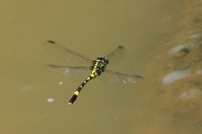
Behaviour
Not much is known about the Great Hooktail. It mostly perches on trees, both next to the water and in woodland above the riverbank. The Great Hooktail often sits fairly high up. It is also known to sit on the tips of reeds and sometimes on rocks near the water. Females have been observed depositing their eggs at rocky river sections with shallow, fast-flowing water. It hunts from a perch and has a fast, powerful flight.
The Great Hooktail is most active from October to April. See Phenology below.
Amakhosi Game Reserve, KwaZulu-Natal
Photo by Ryan Tippett
Status and Conservation
Paragomphus magnus is an uncommon and localised species. It was first recorded in South Africa as recently as 2012. It is listed as of Least Concern in the IUCN Red List of Threatened Species.
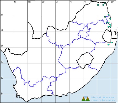
Distribution
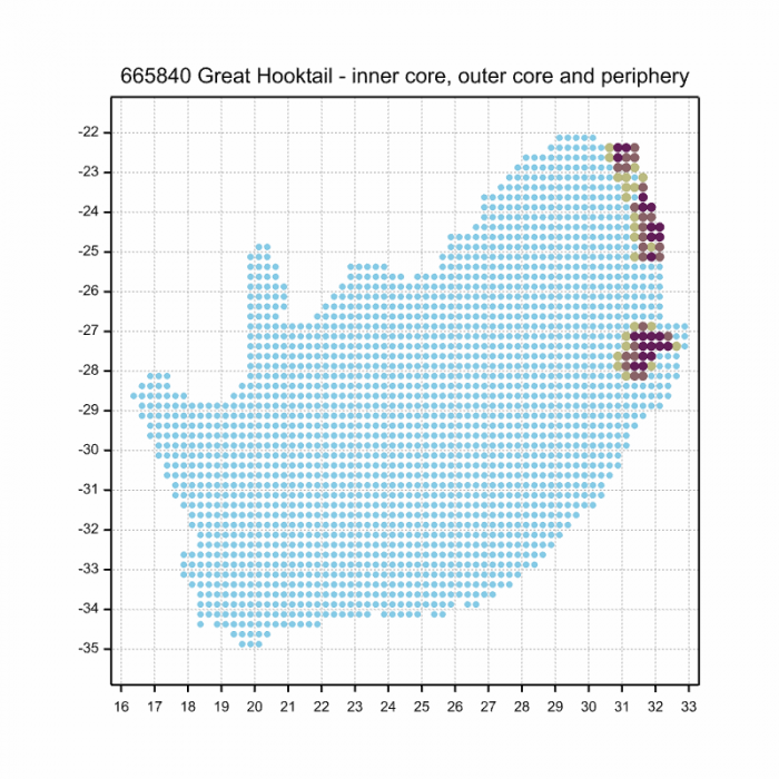
The Great Hooktail is very thinly distributed from northern South Africa, Zimbabwe, and Mozambique up to Malawi, Tanzania, and Kenya. In South Africa, the Great Hooktail has only been recorded from several localities in northeastern KwaZulu-Natal, and the Limpopo and Mpumalanga lowveld.
Below is a map showing the distribution of records for South Africa for the Great Hooktail. Taken from the OdonataMAP database as at February 2020.
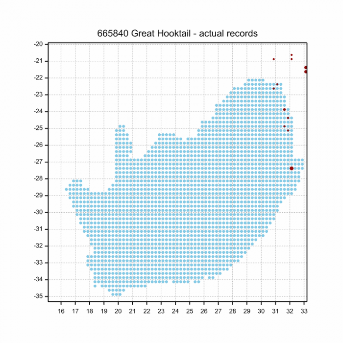
Below is a map showing the distribution of records for South Africa for the Great Hooktail. Taken from the OdonataMAP database as of December 2024.
The next map below is an imputed map, produced by an interpolation algorithm, which attempts to generate a full distribution map from the partial information in the map above. This map will be improved by the submission of records to the OdonataMAP section of the Virtual Museum.
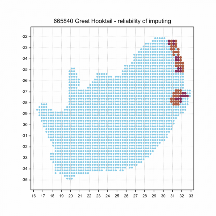
Ultimately, we will produce a series of maps for all the odonata species in the region. The current algorithm is a new algorithm. The objective is mainly to produce “smoothed” maps that could go into a field guide for odonata. This basic version of the algorithm (as mapped above) does not make use of “explanatory variables” (e.g. altitude, terrain roughness, presence of freshwater — we will be producing maps that take these variables into account soon). Currently, it only makes use of the OdonataMAP records for the species being mapped, as well as all the other records of all other species. The basic maps are “optimistic” and will generally show ranges to be larger than what they probably are.
These maps use the data in the OdonataMAP section of the Virtual Museum, and also the database assembled by the previous JRS funded project, which was led by Professor Michael Samways and Dr KD Dijkstra.
Pongola River, KwaZulu-Natal
Photo by Ryan Tippett
Further Resources
The use of photographs by Wil Leurs is acknowledged. Other photographs by Ryan Tippett.
Great Hooktail Paragomphus magnus Fraser, 1952
Other common names: Groothakiestert (Afrikaans)
Recommended citation format: Loftie-Eaton M; Navarro R; Tippett RM; Underhill L. 2025. Great Hooktail Paragomphus magnus. Biodiversity and Development Institute. Available online at https://thebdi.org/2020/06/08/great-hooktail-paragomphus-magnus/
References: Tarboton, M; Tarboton, W. (2019). A Guide to the Dragonflies & Damselflies of South Africa. Struik Nature.
Samways, MJ. (2008). Dragonflies and Damselflies of South Africa. Pensoft
Samways, MJ. (2016). Manual of Freshwater Assessment for South Africa: Dragonfly Biotic Index. Suricata 2. South African National Biodiversity Institute, Pretoria
Martens, A; Suhling, F. (2007). Dragonflies and Damselflies of Namibia. Gamsberg Macmillan.