Cover photo by Joe Smereczansky.
Find this species in the FBIS database (Freshwater Biodiversity Information System) here.
Family Libellulidae
The Cape Skimmer is often considered a subspecies of the Julia Skimmer Orthetrum julia falsum. Some authorities treat them as separate species. The differences between them are clear enough that they are treated separately here.
Identification

Marloth Nature Reserve, Western Cape
Photo by Ryan Tippett
Medium sized
Length around 57mm; Wingspan around 74mm.
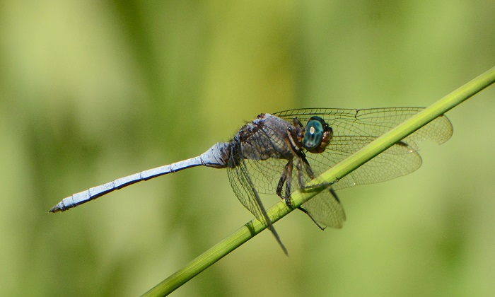
The Cape Skimmer is fairly easy to recognise and it is by far the most common Orthetrum species within its range.
The Cape Skimmer is most similar to Orthetrum julia falsum (Julia Skimmer) and Orthetrum chrysostigma (Epaulet Skimmer). It can be differentiated from Julia Skimmer by having yellowish pterostigmas, black claspers, and a broad grey-white band on the sides of the thorax. The secondary genitalia of O. capicola and O. julia are very similar.

Moordkuil River, Western Cape
Photo by Ryan Tippett
The Cape Skimmer is distinguished from the Epaulet Skimmer Orthetrum chrysostigma by its differently shaped secondary genitalia, and by the thorax stripe, which is irregular and broader at the bottom. The thorax stripe on the Epaulet Skimmer is narrower and of even width.

Montagu, Western Cape
Photo by Ryan Tippett
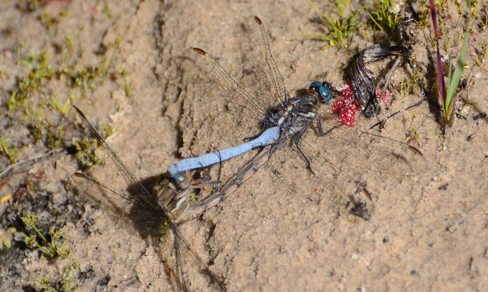
The females are unusual in that they are more recognisable than the males. They have an overall colour ranging from dark pinkish through to red-brown with black lines. They also have two conspicuous white stripes on the sides of the thorax.
Click here for more details on identification.
Habitat
The Cape Skimmer inhabits a wide range of habitats, from rivers and streams to marshes, ponds, and dams. It occupies both still and flowing waters in open or wooded environments. Non-breeding individuals are often found away from water in the surrounding habitats.

Photo by sharon Stanton
Behaviour
The Cape Skimmer often perches on the ground, but also on rocks and exposed stems and twigs. It hunts from a perch with a rapid, darting flight, frequently returning to the same site. Both sexes can be found in the same vicinity. Non-breeding individuals are regularly found hunting away from water in the surrounding habitats.
The Cape Skimmer flies from October to April.
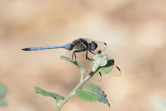
Near Paarl, Western Cape
Photo by Ryan Tippett
Status and Conservation
The Cape Skimmer is very common wherever it occurs. It is listed as of Least Concern in the IUCN Red List of Threatened Species. The Cape Skimmer is highly adaptable and inhabits any suitable habitat, natural or man-made.
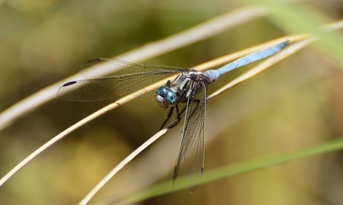
Cedarberg Wilderness area, Western Cape
Photo by Ryan Tippett
Distribution
Orthetrum julia capicola is endemic to South Africa. It occurs throughout the Western Cape, the southern parts of the Eastern Cape, and marginally into the Northern Cape.
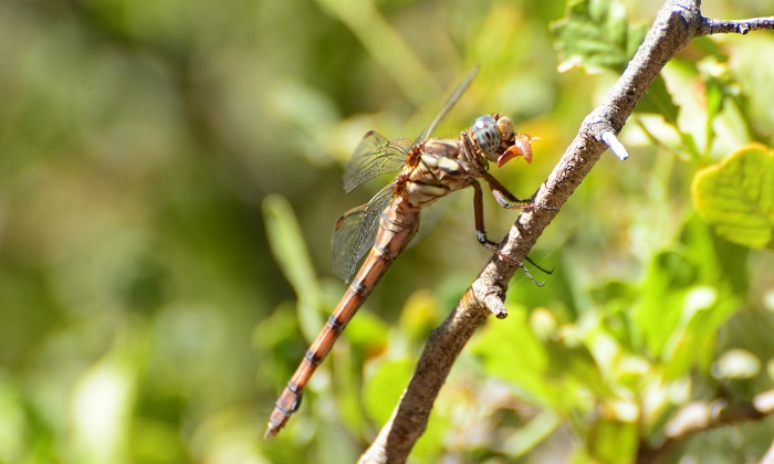
Vanrhynsdorp Waterfall, Western Cape
Photo by Ryan Tippett
Below is a map showing the distribution records for the Cape Skimmer in the OdonataMAP database as of February 2020.

Below is a map showing the distribution records for the Cape Skimmer in the OdonataMAP database as of December 2024.
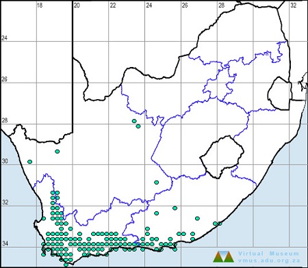
The next map below is an imputed map, produced by an interpolation algorithm, which attempts to generate a full distribution map from the partial information in the map above. This map will be improved by the submission of records to the OdonataMAP section of the Virtual Museum.


Ultimately, we will produce a series of maps for all the odonata species in the region. The current algorithm is a new algorithm. The objective is mainly to produce “smoothed” maps that could go into a field guide for odonata. This basic version of the algorithm (as mapped above) does not make use of “explanatory variables” (e.g. altitude, terrain roughness, presence of freshwater — we will be producing maps that take these variables into account soon). Currently, it only makes use of the OdonataMAP records for the species being mapped, as well as all the other records of all other species. The basic maps are “optimistic” and will generally show ranges to be larger than what they probably are.
These maps use the data in the OdonataMAP section of the Virtual Museum, and also the database assembled by the previous JRS funded project, which was led by Professor Michael Samways and Dr KD Dijkstra.
Near Hanover, Northern Cape
Photo by Ryan Tippett
Further Resources
The use of photographs by Joe Smereczansky and Sharon Stanton. Other photographs by Ryan Tippett.
Cape Skimmer Orthetrum julia capicola Calvert, 1893
Other common names: Kaapse Skepper (Afrikaans)
Recommended citation format: Loftie-Eaton M; Navarro R; Tippett RM; Underhill L. 2025. Cape Skimmer Orthetrum julia capicola. Biodiversity and Development Institute. Available online at https://thebdi.org/2020/06/19/cape-skimmer-orthetrum-julia-capicola/
References: Tarboton, M; Tarboton, W. (2019). A Guide to the Dragonflies & Damselflies of South Africa. Struik Nature.
Samways, MJ. (2008). Dragonflies and Damselflies of South Africa. Pensoft
Samways, MJ. (2016). Manual of Freshwater Assessment for South Africa: Dragonfly Biotic Index. Suricata 2. South African National Biodiversity Institute, Pretoria
Klein Cedarberg Private Nature Reserve, Western Cape
Photo by Ryan Tippett
