

Cover photo by Niall Perrins.
Find the Bottletail in the FBIS database (Freshwater Biodiversity Information System) here.
Family Libellulidae
Identification

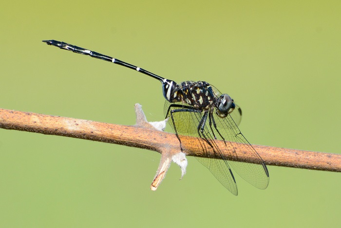
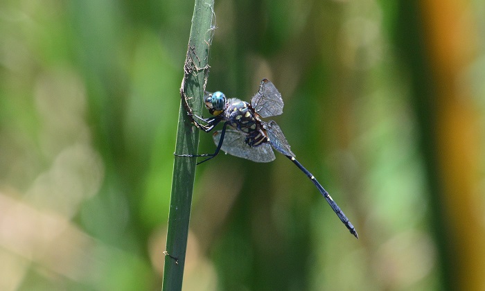
Okavango Delta, Botswana
Photo by Ryan Tippett
Large Size
Length up to 62mm; Wingspan attains 89mm.
The Bottletail is an unmistakable species and it is the only member of its genus. Both sexes are similar in appearance and easily recognised by their long and very thin abdomens. The abdomen base is also noticeably swollen.
The Bottletail is most similar to the Southern Riverking (Zygonoides fuelleborni), but that species has a noticeably broad abdomen that tapers near the waist.
Click here for more details on identification of the Bottletail.
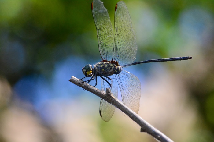
Okavango Delta, Botswana
Photo by Ryan Tippett
Habitat
The Bottletail is a riverine species that frequents both seasonal and perennial rivers, mostly in hot savanna areas. It prefers shallow, flowing sections of rivers with a sandy substrate, especially where flanked by tall reeds, papyrus, or trees.

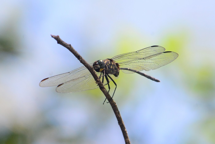
Ndumo Game Reserve, KwaZulu-Natal
Photo by Ryan Tippett
Behaviour
The Bottletail usually sits fairly low down along the inside of river channels, perching prominently on reed stems and tree branches over the river. Both sexes typically occur in the same areas. The Bottletail hunts from a perch, taking off to hawk flying insects or to chase off rivals in fast, agile flight. In hot weather, they may retreat to shadier perches under the canopy of trees. Non-breeding individuals can often be found a short distance from the river in the surrounding habitat. The Bottletail is on the wing from December to May.
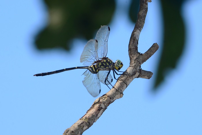
Pongola River, KwaZulu-Natal
Photo by Ryan Tippett
Status and Conservation
The Bottletail is uncommon and localised in South Africa. It is more common in other regions further north such as the Okavango Delta in Botswana. The Bottletail is listed locally as Near Threatened in the IUCN Red List Of Threatened Species. The global listing for Olpogastra lugubris is of Least Concern.
Ndumo Game Reserve, KwaZulu-Natal
Photo by Ryan Tippett
Distribution
The Bottletail is widespread throughout most of Sub-Saharan Africa. In South Africa, Olpogastra lugubris is mostly confined to the warmer north-east, with most records coming from Limpopo, Mpumalanga, and KwaZulu-Natal. The Bottletail is also present along the upper Vaal River and may be more widespread along the Vaal and Orange Rivers than current records show.
Below is a map showing the distribution of records for Bottletail in the OdonataMAP database as at February 2020.

Below is a map showing the distribution of records for Bottletail in the OdonataMAP database as of December 2024.
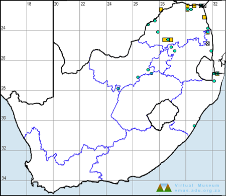
The next map below is an imputed map, produced by an interpolation algorithm, which attempts to generate a full distribution map from the partial information in the map above. This map will be improved by the submission of records to the OdonataMAP section of the Virtual Museum.


Ultimately, we will produce a series of maps for all the odonata species in the region. The current algorithm is a new algorithm. The objective is mainly to produce “smoothed” maps that could go into a field guide for odonata. This basic version of the algorithm (as mapped above) does not make use of “explanatory variables” (e.g. altitude, terrain roughness, presence of freshwater — we will be producing maps that take these variables into account soon). Currently, it only makes use of the OdonataMAP records for the species being mapped, as well as all the other records of all other species. The basic maps are “optimistic” and will generally show ranges to be larger than what they probably are.
These maps use the data in the OdonataMAP section of the Virtual Museum, and also the database assembled by the previous JRS funded project, which was led by Professor Michael Samways and Dr KD Dijkstra.
Pongola River, KwaZulu-Natal
Photo by Ryan Tippett
Further Resources
The use of photographs by Niall Perrins is acknowledged. All other photographs by Ryan Tippett.
Bottletail Olpogastra lugubris Karsch, 1895
Other common names: Slender Bottletail (Alt. English); Lenige Bottelstert (Afrikaans)
Recommended citation format: Loftie-Eaton M; Navarro R; Tippett RM; Underhill L. 2025. Bottletail Olpogastra lugubris. Biodiversity and Development Institute. Available online at https://thebdi.org/2020/06/19/bottletail-olpogastra-lugubris/
References: Tarboton, M; Tarboton, W. (2019). A Guide to the Dragonflies & Damselflies of South Africa. Struik Nature.
Samways, MJ. (2008). Dragonflies and Damselflies of South Africa. Pensoft
Samways, MJ. (2016). Manual of Freshwater Assessment for South Africa: Dragonfly Biotic Index. Suricata 2. South African National Biodiversity Institute, Pretoria
Martens, A; Suhling, F. (2007). Dragonflies and Damselflies of Namibia. Gamsberg Macmillan.
Pongola River, KwaZulu-Natal
Photo by Ryan Tippett