
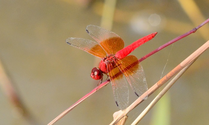
Cover photo by Rob Dickinson.
Find this species in the FBIS database (Freshwater Biodiversity Information System) here.
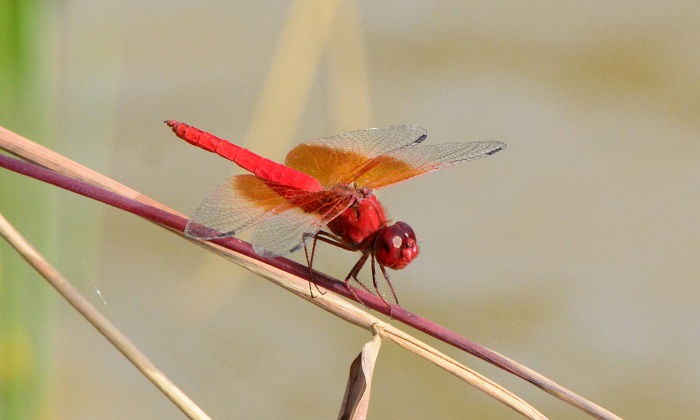
Family Libellulidae
Identification
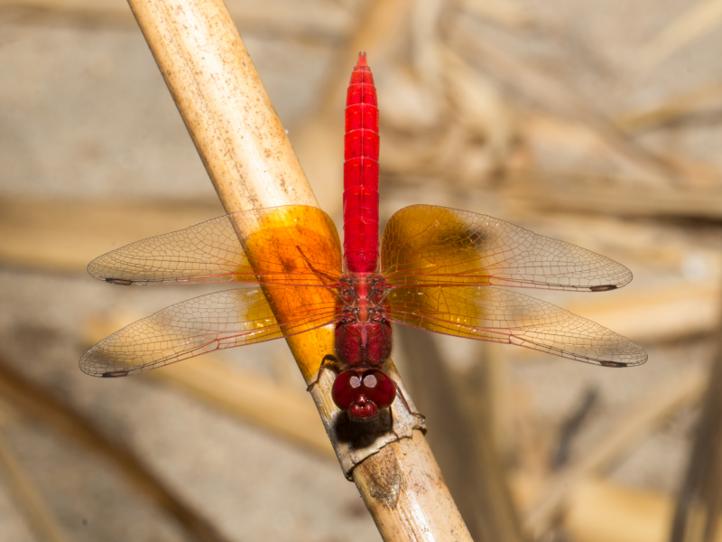
Mkuze River, KwaZulu-Natal
Photo by Ryan Tippett
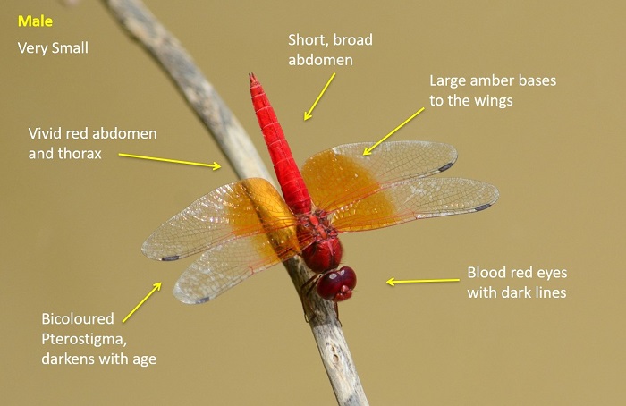
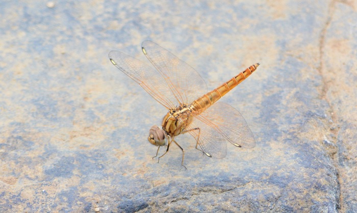
Very small size
Length up to 27mm; Wingspan reaches 49mm.
Male Red Groundlings are most similar to the Orange-winged Dropwing (Trithemis kirbyi). Both species are bright red with amber wing panels. Brachythemis lacustris differs in having a squat build, with shorter, broader abdomens and an un-tapered waist. In addition Brachythemis lacustris has bi-coloured pterostigmas and deep red-brown eyes with dark lateral lines.
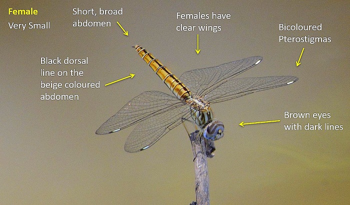
Females also differ from Trithemis kirbyi by having a squat build, bi-coloured pterostigmas, different abdomen patterns and eyes with dark lateral lines.
Click here for more details on identification.
Ndumo Game Reserve, KwaZulu-Natal
Photp by Ryan Tippett
Habitat
The Red Groundling inhabits rivers and streams with an abundance of bank side reeds, sedges, trees, grass and other vegetation. It often frequents backwaters and small, meandering channels where the water flow is weaker. The Red Groundling occurs mainly in the warmer and wetter parts of the Savanna biome.
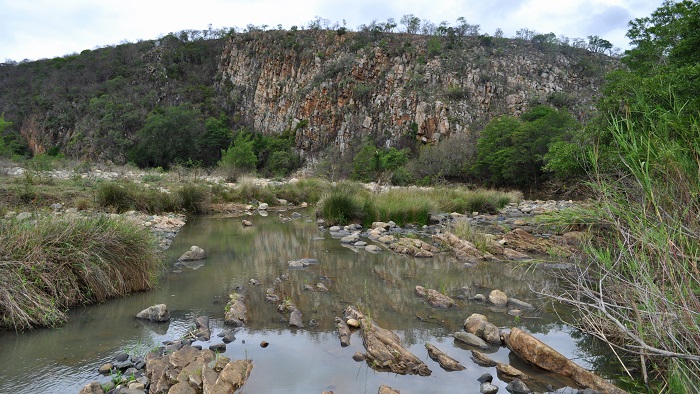
Photo by Ryan Tippett
Behaviour
The Red Groundling is a gregarious species. Many individuals of both sexes and of varying ages, may be found on the same overhanging reed. It is rather inconspicuous, despite the males bright colouration, as they tend to sit low down along the inside of river channels. The Red Groundling is fairly confiding and reluctant to fly. It hunts small flying insect in short, darting flights before quickly returning to a perch.
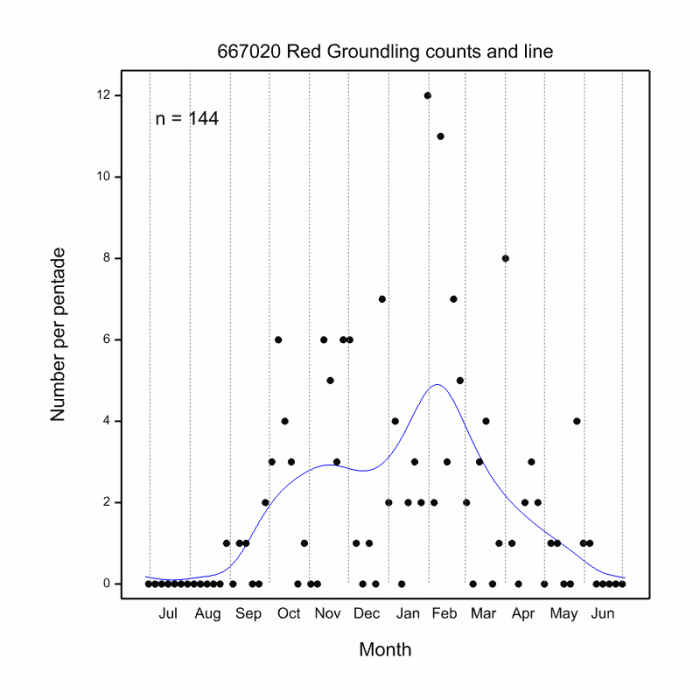
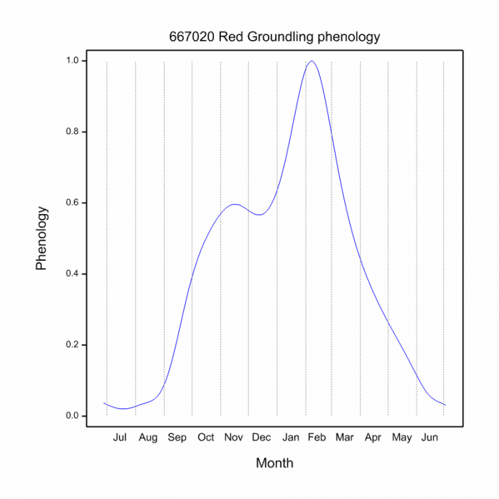
The Red Groundling is most active from late September to May (see Phenology below)

Mkuze River, KwaZulu-Natal
Photo by Ryan Tippett
Status and Conservation
Brachythemis lacustris is fairly common but highly localised. It is listed as of Least Concern in the IUCN Red List of Threatened Species. It is fairly sensitive to habitat disturbance and is found primarily in undisturbed habitats.
Amakhosi Game Reserve, KwaZulu-Natal
Photo by Ryan Tippett
Distribution
The Red Groundling is widely distributed over most of sub-Saharan Africa. In Southern Africa it is absent from the arid Kalahari, Namib and Karoo regions, as well as the more temperate Eastern and Western Cape provinces.
Below is a map showing the distribution of records for Red Groundling in the OdonataMAP database as at February 2020.
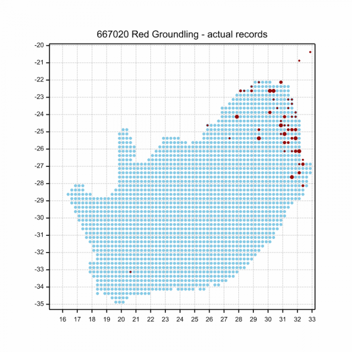
Below is a map showing the distribution of records for Red Groundling in the OdonataMAP database as of December 2024.
The next map below is an imputed map, produced by an interpolation algorithm, which attempts to generate a full distribution map from the partial information in the map above. This map will be improved by the submission of records to the OdonataMAP section of the Virtual Museum.
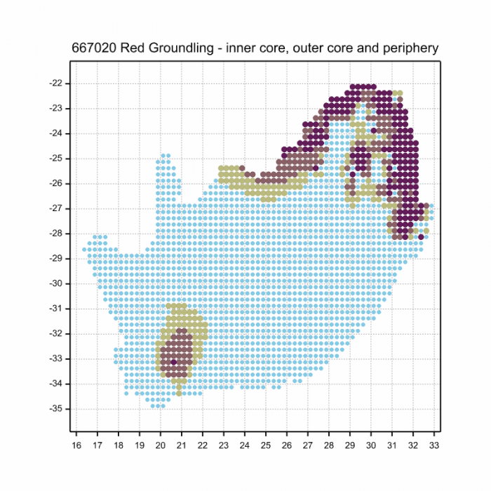
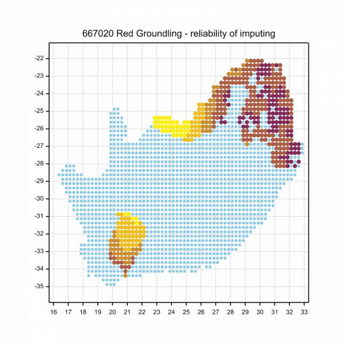
Ultimately, we will produce a series of maps for all the odonata species in the region. The current algorithm is a new algorithm. The objective is mainly to produce “smoothed” maps that could go into a field guide for odonata. This basic version of the algorithm (as mapped above) does not make use of “explanatory variables” (e.g. altitude, terrain roughness, presence of freshwater — we will be producing maps that take these variables into account soon). Currently, it only makes use of the OdonataMAP records for the species being mapped, as well as all the other records of all other species. The basic maps are “optimistic” and will generally show ranges to be larger than what they probably are.
These maps use the data in the OdonataMAP section of the Virtual Museum, and also the database assembled by the previous JRS funded project, which was led by Professor Michael Samways and Dr KD Dijkstra.

Mkuze River, KwaZulu-Natal
Photo by Ryan Tippett
Phenology
Mkuze River, KwaZulu-Natal
Photo by Ryan Tippett
Further Resources
The use of photographs by Rob Dickinson is acknowledged. All other photographs by Ryan Tippett.
Red Groundling Brachythemis lacustris (Kirby, 1889)
Other common names: Rooigrondwagtertjie (Afrikaans)
Recommended citation format: Loftie-Eaton M; Navarro R; Tippett RM; Underhill L. 2025. Red Groundling Brachythemis lacustris. Biodiversity and Development Institute. Available online at https://thebdi.org/2020/06/12/red-groundling-brachythemis-lacustris/
References: Tarboton, M; Tarboton, W. (2019). A Guide to the Dragonflies & Damselflies of South Africa. Struik Nature.
Samways, MJ. (2008). Dragonflies and Damselflies of South Africa. Pensoft
Samways, MJ. (2016). Manual of Freshwater Assessment for South Africa: Dragonfly Biotic Index. Suricata 2. South African National Biodiversity Institute, Pretoria
Martens, A; Suhling, F. (2007). Dragonflies and Damselflies of Namibia. Gamsberg Macmillan.
Amakhosi Game Reserve, KwaZulu-Natal
Photo by Ryan Tippett