
Cover photo by Bernardine Altenroxel.
Find the Two-banded Cruiser in the FBIS database (Freshwater Biodiversity Information System) here.
Family Macromiidae
Identification

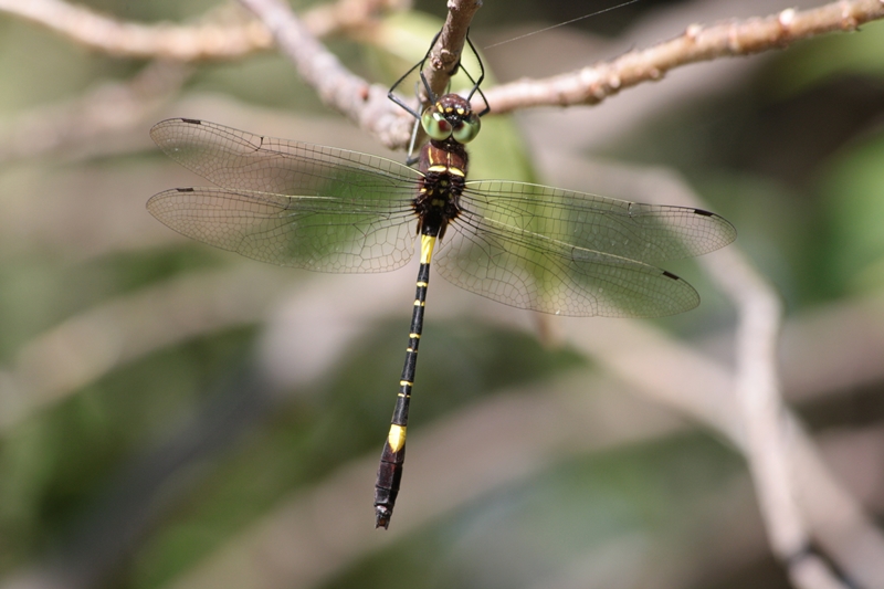
Limpopo Transfrontier Park, Mozambique
Photo by Gerhardt Diedericks
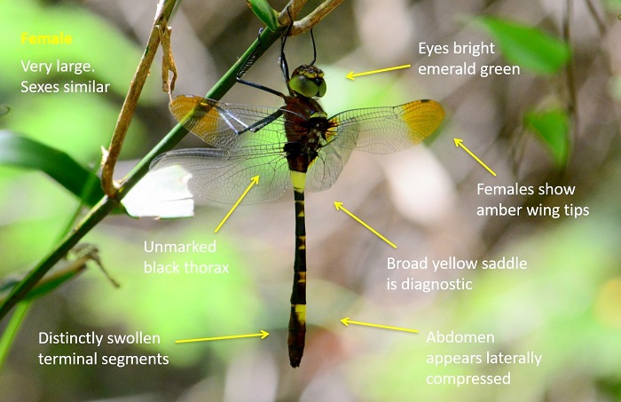
Very large
Length up to 68mm; Wingspan attains 103mm.
The Two-banded Cruiser is recognisable as a Phyllomacromia species by its large size, striking black and yellow colouration, and bright emerald green eyes.
It is most similar to the Sable Cruiser (Phyllomacromia monoceros) and the Darting Cruiser (Phyllomacromia picta). The Two-banded cruiser can be differentiated by being noticeably larger and by having an unmarked glossy black/brown thorax. The sexes are closely similar, but females have slightly broader abdomens with a less pronounced ‘club’.
Click here for more details on identification of the Two-banded Cruiser.
Enseleni Nature Reserve, KwaZulu-Natal
Photo by Ryan Tippett
Habitat
The Two-banded Cruiser frequents the margins of rivers, lakes, pans, and marshes in savanna and forest regions. It is most numerous in habitats where there is a patchwork of wetland and woodland. The Two-banded Cruiser is often found away from water, hunting in woodland clearings and along roads. This species is most abundant in humid regions.

Photo by Ryan Tippett
Behaviour
The Two-banded Cruiser is highly aerial and is most often encountered in flight, but can occasionally be found perched. It hangs vertically from a perch when at rest. Patrols back and forth along a chosen course, along the edge of a wetland, around the treetops, or along a road or clearing.
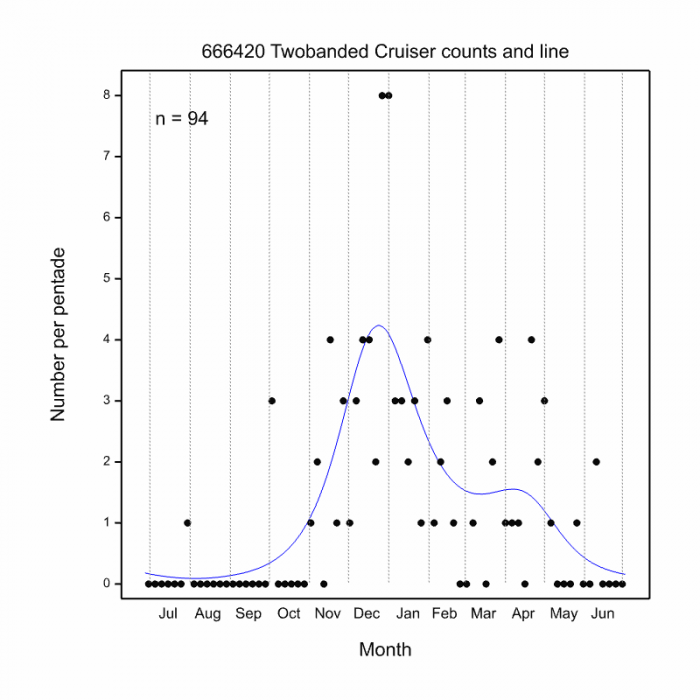
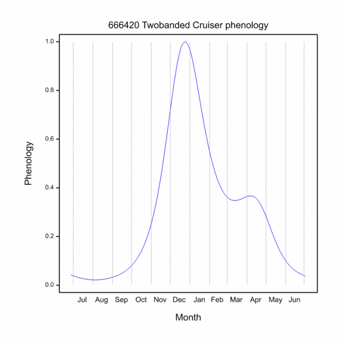
The Two-banded Cruiser is active from October to May, but may fly year-round in warmer areas. See Phenology below.

Mkuze River, KwaZulu-Natal
Photo by Ryan Tippett
Status and Conservation
The Two-banded Cruiser is locally common. It is listed as of Least Concern in the IUCN Red List of Threatened Species. It is a fairly adaptable species and is frequently found around suitable man-made habitats.
Distribution
Phyllomacromia contumax is widespread in Sub-Saharan Africa. It is absent only from the arid regions of north-east Africa and the western parts of southern Africa. In South Africa, the Two-banded Cruiser occurs widely in the north and east. It is most abundant in north-eastern KwaZulu-Natal.

Linyanti, Botswana
Photo by Ryan Tippett
Below is a map showing the distribution of records for Two-banded Cruiser in the OdonataMAP database as at February 2020.
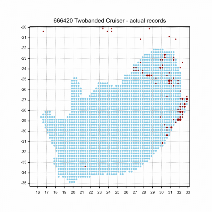
Below is a map showing the distribution of records for Two-banded Cruiser in the OdonataMAP database as of December 2024.

The next map below is an imputed map, produced by an interpolation algorithm, which attempts to generate a full distribution map from the partial information in the map above. This map will be improved by the submission of records to the OdonataMAP section of the Virtual Museum.
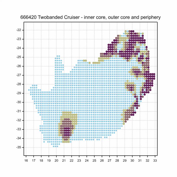
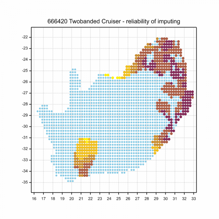
Ultimately, we will produce a series of maps for all the odonata species in the region. The current algorithm is a new algorithm. The objective is mainly to produce “smoothed” maps that could go into a field guide for odonata. This basic version of the algorithm (as mapped above) does not make use of “explanatory variables” (e.g. altitude, terrain roughness, presence of freshwater — we will be producing maps that take these variables into account soon). Currently, it only makes use of the OdonataMAP records for the species being mapped, as well as all the other records of all other species. The basic maps are “optimistic” and will generally show ranges to be larger than what they probably are.
These maps use the data in the OdonataMAP section of the Virtual Museum, and also the database assembled by the previous JRS funded project, which was led by Professor Michael Samways and Dr KD Dijkstra.

Enseleni Nature Reserve, KwaZulu-Natal
Photo by Ryan Tippett
Phenology

Hluhluwe district, KwaZulu-Natal
Photo by Ryan Tippett
Further Resources
The use of photographs by Bernardine Altenroxel and Gerhardt Diedericks is acknowledged. All other photographs by Ryan Tippett.
Two-banded Cruiser Phyllomacromia contumax Selys, 1879
Other common names: Dubbelbandswalker (Afrikaans)
Recommended citation format: Loftie-Eaton M; Navarro R; Tippett RM; Underhill L. 2025. Two-banded Cruiser Phyllomacromia contumax. Biodiversity and Development Institute. Available online at https://thebdi.org/2020/06/09/two-banded-cruiser-phyllomacromia-contumax/
References: Tarboton, M; Tarboton, W. (2019). A Guide to the Dragonflies & Damselflies of South Africa. Struik Nature.
Samways, MJ. (2008). Dragonflies and Damselflies of South Africa. Pensoft
Samways, MJ. (2016). Manual of Freshwater Assessment for South Africa: Dragonfly Biotic Index. Suricata 2. South African National Biodiversity Institute, Pretoria
Martens, A; Suhling, F. (2007). Dragonflies and Damselflies of Namibia. Gamsberg Macmillan.