

Cover photo by Rob Dickinson.
Find the Gracious Wisp in the FBIS database (Freshwater Biodiversity Information System) here.
Family Coenagrionidae
Identification

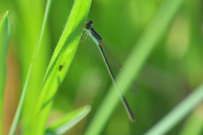
Okavango Delta, Botswana
Photo by Ryan Tippett
Very small size
Length up to 26mm; Wingspan attains 28mm.
The Gracious Wisp is most similar to Agriocnemis falcifera (White-masked Wisp). The Gracious Wisp can be told apart by its round postocular spots that are not joined by a thin line. Additionally, the male Gracious Wisp lacks the white moustache of the White-masked Wisp. These two species are the largest Southern African wisps, which helps to separate them from the other smaller species.
Click here for more details on identification.
Habitat
The Gracious Wisp is associated with the fringes and clearings of riverine, coastal, swamp, and dune forests. It occupies damp, grassy areas linked to slow-moving streams, pools, pans, and marshes. The Gracious Wisp favours sites with a rich growth of tall grasses, ferns, and other herbaceous plants. It is often found in shady areas with dappled light.

Photo by Ryan Tippett
Behaviour
Due to its small size, the Gracious Wisp is an unobtrusive species that hides low down among rank vegetation.
It is most active from October to April (See Phenology below).
Status and Conservation
The Gracious Wisp is scarce and very localised in South Africa. It is listed in the IUCN Red List of Threatened Species as Vulnerable in South Africa, but of Least Concern overall.
Kosi Bay, iSimangaliso Wetland Park, KwaZulu-Natal
Photo by Ryan Tippett
Distribution
The Gracious Wisp is a species of East and Southern Africa. It has been recorded in Botswana, the Democratic Republic of the Congo, Kenya, Madagascar, Malawi, Mozambique, Namibia, South Africa, Sudan, Tanzania, Uganda, Zambia, and possibly Burundi.
In South Africa, the Gracious Wisp is restricted to the coastal region of north-eastern KwaZulu-Natal, reaching as far south as Amanzimtoti. It is also found locally at a few scattered sites in the Lowveld of Mpumalanga and Limpopo.
Below is a map showing the distribution of records for Gracious Wisp in the OdonataMAP database as at February 2020.

Below is a map showing the distribution of records for Gracious Wisp in the OdonataMAP database as of Decewmber 2024.
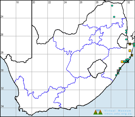
The next map below is an imputed map, produced by an interpolation algorithm, which attempts to generate a full distribution map from the partial information in the map above. This map will be improved by the submission of records to the OdonataMAP section of the Virtual Museum.


Ultimately, we will produce a series of maps for all the odonata species in the region. The current algorithm is a new algorithm. The objective is mainly to produce “smoothed” maps that could go into a field guide for odonata. This basic version of the algorithm (as mapped above) does not make use of “explanatory variables” (e.g. altitude, terrain roughness, presence of freshwater — we will be producing maps that take these variables into account soon). Currently, it only makes use of the OdonataMAP records for the species being mapped, as well as all the other records of all other species. The basic maps are “optimistic” and will generally show ranges to be larger than what they probably are.
These maps use the data in the OdonataMAP section of the Virtual Museum, and also the database assembled by the previous JRS funded project, which was led by Professor Michael Samways and Dr KD Dijkstra.
Phenology


Further Resources
The use of photographs by Rob Dickinson is acknowledged. Other photographs by Ryan Tippett.
Gracious Wisp Agriocnemis gratiosa Gerstäcker, 1891
Other common names: Grasieuse Soetjie (Afrikaans)
Recommended citation format: Loftie-Eaton M; Navarro R; Tippett RM; Underhill L. 2025. Gracious Wisp Agriocnemis gratiosa. Biodiversity and Development Institute. Available online at https://thebdi.org/2020/04/22/gracious-wisp-agriocnemis-gratiosa/
References: Tarboton, M; Tarboton, W. (2019). A Guide to the Dragonflies & Damselflies of South Africa. Struik Nature.
Samways, MJ. (2008). Dragonflies and Damselflies of South Africa. Pensoft.
Samways, MJ. (2016). Manual of Freshwater Assessment for South Africa: Dragonfly Biotic Index. Suricata 2. South African National Biodiversity Institute, Pretoria.
Martens, A; Suhling, F. (2007). Dragonflies and Damselflies of Namibia. Gamsberg Macmillan.