
Find the Opal Slim in the FBIS database (Freshwater Biodiversity Information System) here.
Family Coenagrionidae
Identification
There are currently no photographs of this species in the OdonataMAP database.
Aciagrion dondoense is a small, elongate, and slender damselfly with a small head. Males are bright greenish-blue on the upper thorax. The sides of the thorax are bright blue. The long, slender abdomen is black above and brownish below. The terminal segments are bright blue, as are the postocular spots.
The Opal Slim is most similar to the Graceful Slim (Aciagrion gracile), which occurs in the same areas. The two species are best differentiated in the hand by the shape of the male claspers.
Habitat
The Opal Slim is found in coastal grassland and forest mosaic, where it inhabits flooded, marshy areas and the grassy fringes of pans.

Photo by Ryan Tippett
Behaviour
The Opal Slim is found low down, close to the water, where it moves about among the grass stems. It is also recorded away from the water in the shade of fringing bush and forest.
In South Africa, the Opal Slim has thus far only been recorded in February (See Phenology below).
Status and Conservation
Very little is currently known about the Opal Slim. It is seemingly rare and erratic in occurrence. The Opal Slim is listed as Vulnerable in the IUCN Red List of Threatened Species.
Distribution
Aciagrion dondoense is only known from central and southern Mozambique, southern Zimbabwe, and north-eastern KwaZulu-Natal in South Africa.
In South Africa, the Opal Slim has only been recorded from Cape Vidal in the iSimangaliso Wetland Park. Records show that it was abundant there following strong cyclonic weather in the early 2000’s. The Opal Slim has not been recorded in South Africa since.
Below is a map showing the distribution of records for Opal Slim in the OdonataMAP database as at February 2020.

Below is a map showing the distribution of records for Opal Slim in the OdonataMAP database as of December 2024.
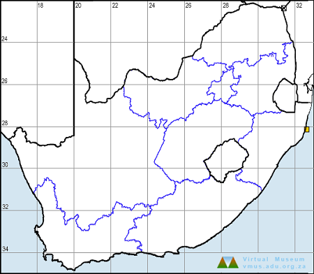
The next map below is an imputed map, produced by an interpolation algorithm, which attempts to generate a full distribution map from the partial information in the map above. This map will be improved by the submission of records to the OdonataMAP section of the Virtual Museum.


Ultimately, we will produce a series of maps for all the odonata species in the region. The current algorithm is a new algorithm. The objective is mainly to produce “smoothed” maps that could go into a field guide for odonata. This basic version of the algorithm (as mapped above) does not make use of “explanatory variables” (e.g. altitude, terrain roughness, presence of freshwater — we will be producing maps that take these variables into account soon). Currently, it only makes use of the OdonataMAP records for the species being mapped, as well as all the other records of all other species. The basic maps are “optimistic” and will generally show ranges to be larger than what they probably are.
These maps use the data in the OdonataMAP section of the Virtual Museum, and also the database assembled by the previous JRS funded project, which was led by Professor Michael Samways and Dr KD Dijkstra.
Phenology

Further Resources
Opal Slim Aciagrion dondoense Dijkstra, 2007
Other common names: Opaalskraaltjie (Afrikaans)
Recommended citation format: Loftie-Eaton M; Navarro R; Tippett RM; Underhill L. 2025. Opal Slim Aciagrion dondoense. Biodiversity and Development Institute. Available online at https://thebdi.org/2020/04/21/opal-slim-aciagrion-dondoense/
References: Tarboton, M; Tarboton, W. (2019). A Guide to the Dragonflies & Damselflies of South Africa. Struik Nature.
Samways, MJ. (2008). Dragonflies and Damselflies of South Africa. Pensoft
Samways, MJ. (2016). Manual of Freshwater Assessment for South Africa: Dragonfly Biotic Index. Suricata 2. South African National Biodiversity Institute, Pretoria