

View the above photo record (by Wil Leurs) in OdonataMAP here.
Find the Coastal Pennant in the FBIS database (Freshwater Biodiversity Information System) here.
Family Libellulidae
Macrodiplax cora – COASTAL PENNANT
(Brauer, 1867)
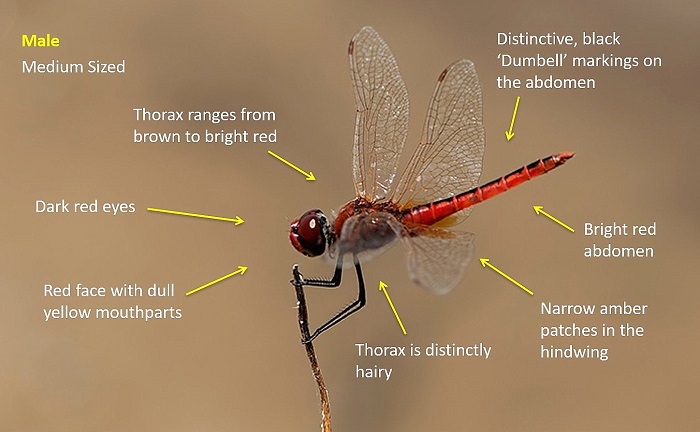
Identification
Medium sized
Length up to 44mm; Wingspan attains 71mm.
The distinctive dumbell-shaped markings along the top of the abdomen are diagnostic in both sexes.
Most likely to be mistaken for Sympetrum fonscolombii, Urothemis assignata or Aethriamanta rezia.
Macrodiplax cora can be recognised by the diagnostic markings on the abdomen, distinctive wing venation and the small, narrow amber panels in the hindwings.
Click here for more details on identification of the Coastal Pennant.
Eastern Shores, iSimangaliso Wetland Park
Photo by Wil Leurs
Habitat
Strictly coastal in South Africa, preferring the grass and sedge fringes of estuaries, marshes and pans. May also be found away from water in coastal grasslands and bush. This species is tolerant of brackish water.
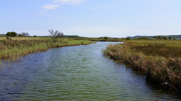
Photo by Ryan Tippett
Behaviour
Perches prominently on top of exposed sticks and other similar perches. Hunts from a perch and has a fast, powerful flight. Often returns to the same perch.
Status and Conservation
In South Africa Macrodiplax cora is scarce and erratic in occurence. The coastal Pennant is listed locally and globally as of Least Concern in the IUCN Red List of Threatened Species. Almost the entirety of its South African range is protected within the iSimangaliso wetland Park. In South Africa it has only been recorded in undamaged habitats.
Distribution
Macrodiplax cora is predominantly an Asian species and is widespread in tropical Asia and Australasia. The species also occurs on a number of Indian and Pacific Ocean Islands.
The occurence of this species in Africa is very interesting. The species has established a small resident population in coastal NE KwaZulu-Natal. Its South African distribution ranges from St. Lucia up to Kosi Bay, and is also likely to occur in the neighboring part of southern Mozambique. In other parts of Africa, it has only been recorded in coastal Somalia and on the island of Socotra.
Below is a map showing the distribution of records for Coastal Pennant in the OdonataMAP database as at February 2020.

The next map below is an imputed map, produced by an interpolation algorithm, which attempts to generate a full distribution map from the partial information in the map above. This map will be improved by the submission of records to the OdonataMAP section of the Virtual Museum.
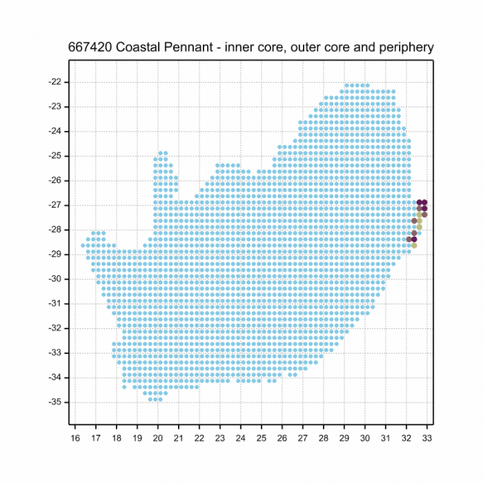
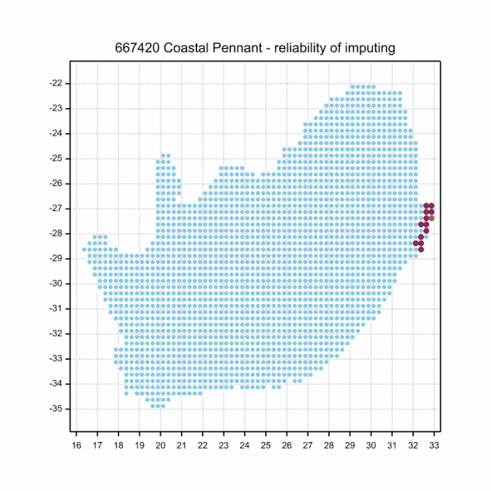
Ultimately, we will produce a series of maps for all the odonata species in the region. The current algorithm is a new algorithm. The objective is mainly to produce “smoothed” maps that could go into a field guide for odonata. This basic version of the algorithm (as mapped above) does not make use of “explanatory variables” (e.g. altitude, terrain roughness, presence of freshwater — we will be producing maps that take these variables into account soon). Currently, it only makes use of the OdonataMAP records for the species being mapped, as well as all the other records of all other species. The basic maps are “optimistic” and will generally show ranges to be larger than what they probably are.
These maps use the data in the OdonataMAP section of the Virtual Museum, and also the database assembled by the previous JRS funded project, which was led by Professor Michael Samways and Dr KD Dijkstra.
Further Resources
Virtual Museum (OdonataMAP > Search VM > By Scientific or Common Name)
More common names: Cora’s Pennant (Alternative English name); Kuswimpel (Afrikaans)
Type Locality: Ceram, Indonesia
Recommended citation format: Loftie Eaton. M; Hofmeyr S; Tippett RM; Underhill L. Coastal Pennant Macrodiplax cora. Biodiversity and Development Institute. Available online at http://thebdi.org/2020/06/19/coastal-pennant-macrodiplax-cora/