

Cover photo by Gary Brown.
Find this species in the FBIS database (Freshwater Biodiversity Information System) here.
Family Libellulidae
Identification

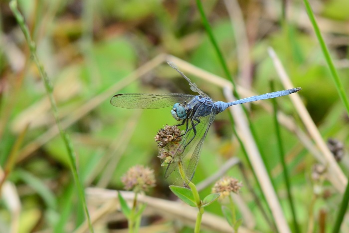
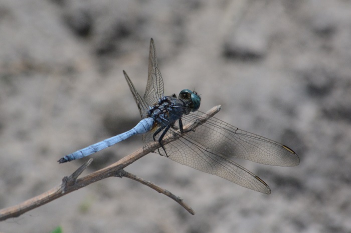
Near Kosi Bay, KwaZulu-Natal
Photo by Ryan Tippett
Medium sized
Length up to 57mm; Wingspan attains 82mm.
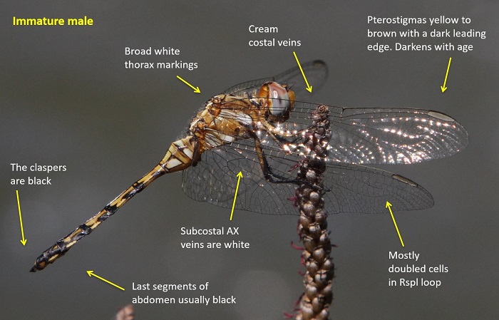
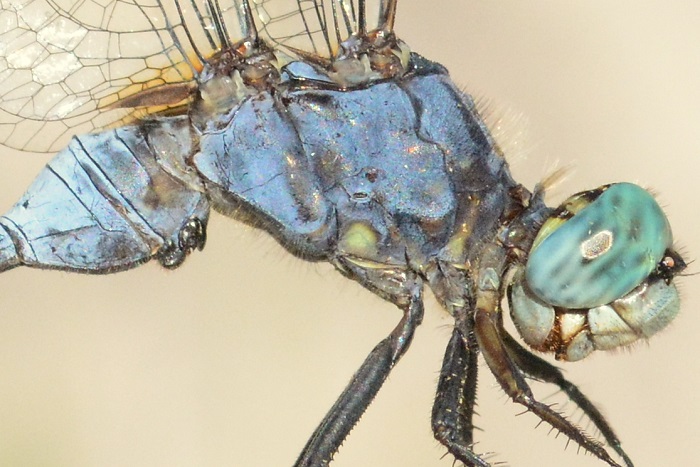
The Banded Skimmer is most like Orthetrum stemmale (Bold Skimmer). The most reliable way to differentiate between the two is by examining the morphology of the secondary genitalia. This needs to be carefully examined as the genitalia are quite similar. Additionally, the cerci/claspers of Orthetrum brachiale are mostly black, while those of Orthetrum stemmale are largely white.
Click here for more details on identification.
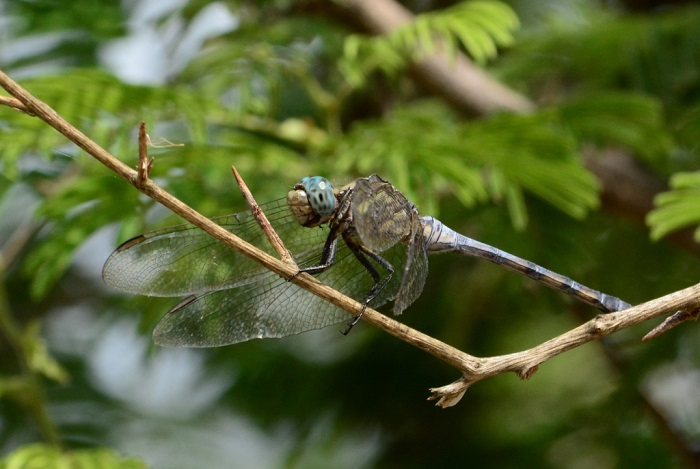
Katanga, Democratic Republic of the Congo
Photo by R. de Cauwer
Habitat
The Banded Skimmer is a savanna species that inhabits the grass, reed, and bush fringes of rivers, streams, pools, dams, and marshes. Non-breeding individuals are often found in woodlands away from the water.

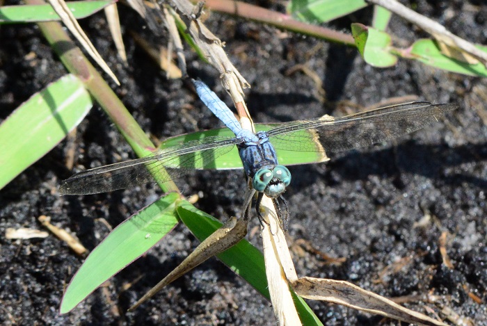
Photo by Ryan Tippett
Behaviour
Breeding individuals are found on waterside vegetation, but they are often observed away from water in the surrounding woodlands. The Banded Skimmer perches on exposed twigs among bushes where it hawks insects in rapid flight.
Near Kosi Bay, KwaZulu-Natal
Photo by Ryan Tippett
Status and Conservation
Seemingly scarce in South Africa. The Banded Skimmer is listed as of Least Concern in the IUCN Red List of Threatened Species.
Okavango Delta, Botswana
Photo by Ryan Tippett
Distribution
The Banded Skimmer is widespread throughout much of Sub-Saharan Africa. It reaches its southern limit in the north-eastern parts of South Africa, where it has possibly been overlooked.
Near Kosi Bay, KwaZulu-Natal
Photo by Ryan Tippett
Below is a map showing the distribution of records for Banded Skimmer in the OdonataMAP database as at February 2020.

Below is a map showing the distribution of records for Banded Skimmer in the OdonataMAP database as of December 2024.
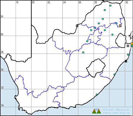
The next map below is an imputed map, produced by an interpolation algorithm, which attempts to generate a full distribution map from the partial information in the map above. This map will be improved by the submission of records to the OdonataMAP section of the Virtual Museum.


Ultimately, we will produce a series of maps for all the odonata species in the region. The current algorithm is a new algorithm. The objective is mainly to produce “smoothed” maps that could go into a field guide for odonata. This basic version of the algorithm (as mapped above) does not make use of “explanatory variables” (e.g. altitude, terrain roughness, presence of freshwater — we will be producing maps that take these variables into account soon). Currently, it only makes use of the OdonataMAP records for the species being mapped, as well as all the other records of all other species. The basic maps are “optimistic” and will generally show ranges to be larger than what they probably are.
These maps use the data in the OdonataMAP section of the Virtual Museum, and also the database assembled by the previous JRS funded project, which was led by Professor Michael Samways and Dr KD Dijkstra.
Selinda, Botswana
Photo by Ryan Tippett
Further Resources
The use of photographs by Gary Brown and R. de Cauwer is acknowledged. All other photographs by Ryan Tippett.
Banded Skimmer Orthetrum brachiale (Palisot de Beauvois, 1817)
Other common names: River Skimmer, Tough Skimmer, Strong Skimmer (Alt. English); Gebande Skepper (Afrikaans)
Recommended citation format: Loftie-Eaton M; Navarro R; Tippett RM; Underhill L. 2025. Banded Skimmer Orthetrum brachiale. Biodiversity and Development Institute. Available online at https://thebdi.org/2020/05/25/banded-skimmer-orthetrum-brachiale/
References: Tarboton, M; Tarboton, W. (2019). A Guide to the Dragonflies & Damselflies of South Africa. Struik Nature.
Samways, MJ. (2008). Dragonflies and Damselflies of South Africa. Pensoft
Samways, MJ. (2016). Manual of Freshwater Assessment for South Africa: Dragonfly Biotic Index. Suricata 2. South African National Biodiversity Institute, Pretoria
Martens, A; Suhling, F. (2007). Dragonflies and Damselflies of Namibia. Gamsberg Macmillan.
Near Kosi Bay, KwaZulu-Natal
Photo by Ryan Tippett