
View the above photo record (by Gregg Darling) can be viewed in OdonataMAP here.
Find the Blue-sided Sprite in the FBIS database (Freshwater Biodiversity Information System) here.
Family Coenagrionidae
Pseudagrion sudanicum – BLUE-SIDED SPRITE
Identification
Small size
Length up to 39mm; Wingspan reaches 51mm.
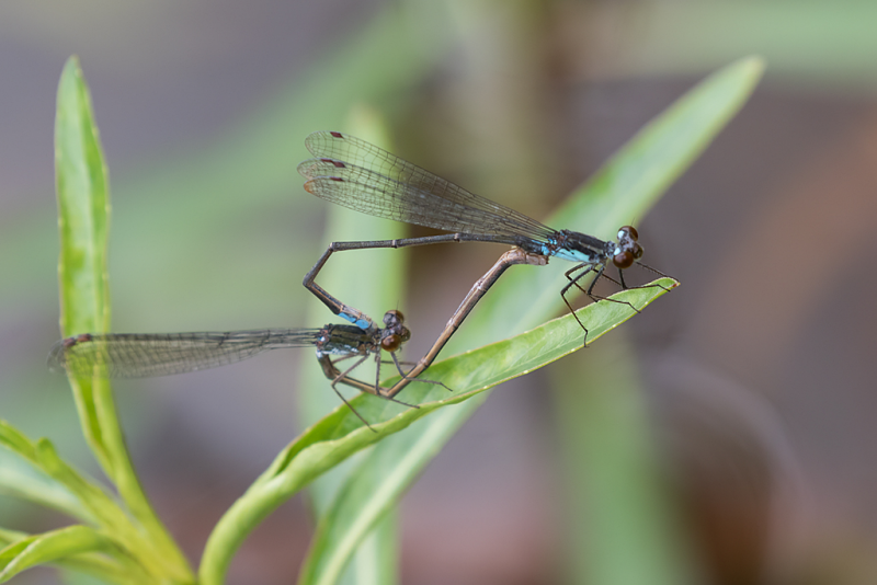
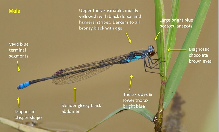
Males are unmistakable and unlike any other South African species. The combination of chocolate brown eyes, large bright blue postocular spots and bright blue thorax sides are diagnostic.
Females are also distinctive being overall orange and black. They are however quite similar to the orange-form females of Ischnura senegalensis (Tropical Bluetail). Female Blue-sided Sprites are larger and more elongate and have thin black antehumeral lines on the the thorax.
Click here for more details on identification.
Nwanedi Resort, Limpopo
Photo by John Wilkinson
Habitat
Inhabits fast flowing rivers in hot savanna regions. Favours sites with an abundance emergent grass, sedge, reeds or papyrus.
Behaviour
Typically perches over the water on emergent vegetation.
On the wing from October to May but may fly all year in some places. See Phenology below.
Status and Conservation
A generally uncommon species. Listed as of Least Concern in the IUCN Red List of Threatened Species.
Distribution
The Blue-sided Sprite is a species of East and Southern Africa, ranging from Sudan in the north down into the NE parts of South Africa.
Below is a map showing the distribution of records for Blue-sided Sprite in the OdonataMAP database as at February 2020.
The next map below is an imputed map, produced by an interpolation algorithm, which attempts to generate a full distribution map from the partial information in the map above. This map will be improved by the submission of records to the OdonataMAP section of the Virtual Museum.
Ultimately, we will produce a series of maps for all the odonata species in the region. The current algorithm is a new algorithm. The objective is mainly to produce “smoothed” maps that could go into a field guide for odonata. This basic version of the algorithm (as mapped above) does not make use of “explanatory variables” (e.g. altitude, terrain roughness, presence of freshwater — we will be producing maps that take these variables into account soon). Currently, it only makes use of the OdonataMAP records for the species being mapped, as well as all the other records of all other species. The basic maps are “optimistic” and will generally show ranges to be larger than what they probably are.
These maps use the data in the OdonataMAP section of the Virtual Museum, and also the database assembled by the previous JRS funded project, which was led by Professor Michael Samways and Dr KD Dijkstra.