

View the above photo record (by Mark Liptrot) in OdonataMAP here.
Find the Dark-shouldered Skimmer in the FBIS database (Freshwater Biodiversity Information System) here.
Family Libellulidae
Orthetrum hintzi – DARK-SHOULDERED SKIMMER
Identification
Small size
Length up to 43mm; Wingspan reaches 64mm.
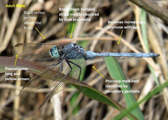
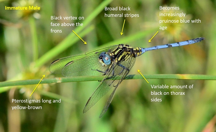
The colouration of the males varies with age. Young (teneral) males resemble the females and have brown eyes and thick black/brown edging along the abdomen. The slightly older immature males begin to develop blue pruinosity that begins to obscure the body patterns. The pruinosity first develops on the abdomen before spreading to the thorax. Mature males are entirely pruinose blue and are best identified by the shape of the secondary genitalia.
Fully pruinose males are very similar to Orthetrum abbotti (Little Skimmer) and the two are best identified by the shape of the males secondary genitalia.
Females are identified by the dark humeral (shoulder) stripes, unmarked thorax sides and the thick black/brown edging along the abdomen.
Click here for more details on identification of the Dark-shouldered Skimmer.
Richards Bay, KwaZulu-Natal
Photo by Diana Russel
Near Kosi Bay, KwaZulu-Natal
Photo by Ryan Tippett

Bokpoort, Limpopo
Photo by Gregg Darling
Habitat
Frequents Bogs, seeps and the marshy fringes of rivers, streams and pans. Prefers habitats rich in grasses. Mostly found in savanna regions.
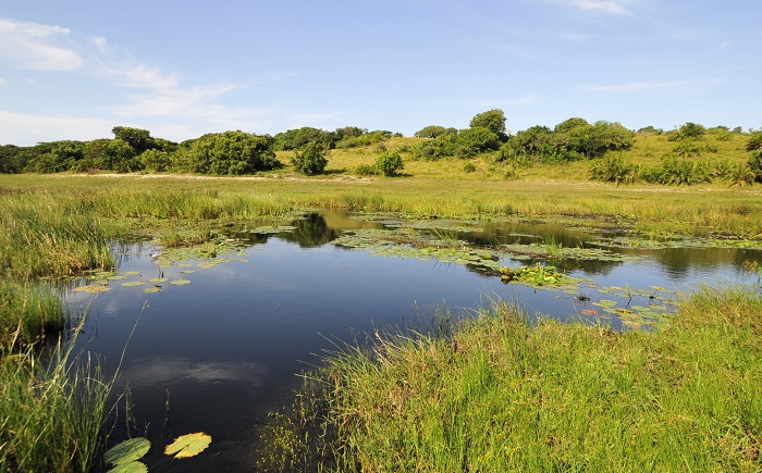
Photo by Ryan Tippett
Behaviour
Perches low to the ground on grass or sedge stems. Seldom sits over open water, preferring boggy ground. The flight is slow and erratic often returning to the same perch. They are fairly tame and confiding and do not normally fly far once disturbed. Both sexes are found in the same area.
Status and Conservation
Locally common and listed as of Least Concern in the IUCN Red List of Threatened Species. Predominantly found in natural habitats and is not tolerant towards habitat degradation.
Distribution
Orthetrum hintzi is widely distributed in sub-Saharan Africa, occurring in West, Central, East and Southern Africa. It is mostly absent from the arid parts of NE Africa and SW Africa.
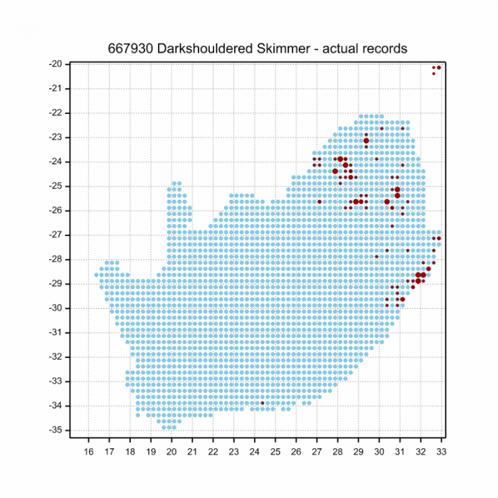
Below is a map showing the distribution of records for Dark-shouldered Skimmer in the OdonataMAP database as at February 2020.
The next map below is an imputed map, produced by an interpolation algorithm, which attempts to generate a full distribution map from the partial information in the map above. This map will be improved by the submission of records to the OdonataMAP section of the Virtual Museum.


Ultimately, we will produce a series of maps for all the odonata species in the region. The current algorithm is a new algorithm. The objective is mainly to produce “smoothed” maps that could go into a field guide for odonata. This basic version of the algorithm (as mapped above) does not make use of “explanatory variables” (e.g. altitude, terrain roughness, presence of freshwater — we will be producing maps that take these variables into account soon). Currently, it only makes use of the OdonataMAP records for the species being mapped, as well as all the other records of all other species. The basic maps are “optimistic” and will generally show ranges to be larger than what they probably are.
These maps use the data in the OdonataMAP section of the Virtual Museum, and also the database assembled by the previous JRS funded project, which was led by Professor Michael Samways and Dr KD Dijkstra.