
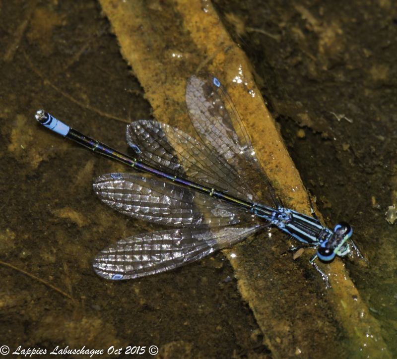
View the above photo record (by Lappies Labuschagne) in OdonataMAP here.
Find the Round-winged Bluet in the FBIS database (Freshwater Biodiversity Information System) here.
Family Coenagrionidae
Proischnura rotundipennis – ROUND-WINGED BLUET
Identification
Very small size
Length up to 22mm; Wingspan reaches 32mm.
Males are most similar to Ischnura senegalensis, Azuragrion nigridorsum and Africallagma glaucum. The Round-winged Bluet can be told apart by the characteristic blue-rimmed pterostigmas, crescent-shaped postocular spots and all black S10.
Females can be mistaken for those of other bluet species. However, they are readily identifiable by their pale blue-rimmed pterostigmas.
Click here for more details on identification.

Near Himeville, KwaZulu-Natal
Photo by Desire Darling
Habitat
This species is found in the grassland biome, where its natural habitat is the grassy verges of slow-flowing streams, ponds and marshes. Sometimes found at dams that offer suitable habitat.

Photo by Corne Rautenbach
Behaviour
Perches prominently on grass and sedge stems over the water.
Active from September to April (see Phenology below).
Status and Conservation
A scarce and localized South African endemic. It is listed as of Least Concern in the IUCN Red List of Threatened Species. Fairly sensitive to habitat degradation. occasionally occurs at suitable man-made habitats.
Distribution
Proischnura rotundipennis is endemic to South Africa. It occurs from the central Eastern Cape, to the interior of KwaZulu-Natal, the eastern FreeState and up to Gauteng, Mpumalanga and as far north as the Soutpansberg in Limpopo.
Below is a map showing the distribution of records for Round-winged Bluet in the OdonataMAP database as at February 2020.

The next map below is an imputed map, produced by an interpolation algorithm, which attempts to generate a full distribution map from the partial information in the map above. This map will be improved by the submission of records to the OdonataMAP section of the Virtual Museum.


Ultimately, we will produce a series of maps for all the odonata species in the region. The current algorithm is a new algorithm. The objective is mainly to produce “smoothed” maps that could go into a field guide for odonata. This basic version of the algorithm (as mapped above) does not make use of “explanatory variables” (e.g. altitude, terrain roughness, presence of freshwater — we will be producing maps that take these variables into account soon). Currently, it only makes use of the OdonataMAP records for the species being mapped, as well as all the other records of all other species. The basic maps are “optimistic” and will generally show ranges to be larger than what they probably are.
These maps use the data in the OdonataMAP section of the Virtual Museum, and also the database assembled by the previous JRS funded project, which was led by Professor Michael Samways and Dr KD Dijkstra.
Phenology

