

View the above photo record (by Jean Hirons) in OdonataMAP here.
Find the Forest Malachite in the FBIS database (Freshwater Biodiversity Information System) here.
Family Synlestidae
Chlorolestes tessellatus – FOREST MALACHITE
Identification
Large. Note that this species can be quite variable in size.
Length up to 57mm; Wingspan attains 72mm.
Males occur in two colour forms. There is a form with conspicuous black and white banding in the wings and a form without the wing bands. Both forms co-occur.
Most likely to be confused with other green malachites that also develop the black and white wing bands. Closest to Chlorolestes fasciatus (Mountain Malachite), from which it differs by having a broad, yellow-brown humeral stripe on the thorax. The Mountain Malachite shows a far thinner, and brighter yellow humeral stripe. The Mountain Malachite is also slightly smaller and generally occurs in more open habitats than the Forest Malachite.
Click here for more details on identification.

Hogsback, Eastern Cape
Photo by Alan Manson
Habitat
This shade-loving species is found mainly at seeps and streams in forests. Also known to inhabit wooded valleys in otherwise dry regions such as in the Swartberg Mountain range.

Photo by Ryan Tippett
Behaviour
An attractive, eye-catching species. Mostly seen hanging from plants over the water with wings outstretched. Mature males are conspicuous in the dappled forest light. Seldom seen away from water. Females are found in the same vicinity as the males but are far more cryptically coloured.
Mostly active from October to May (See Phenology below).
Status and Distribution
Generally scarce and localised but may be common in parts of the Eastern Cape. Listed as of Least Concern in the IUCN Red List of Threatened Species. Moderately sensitive to habitat damage.
Distribution
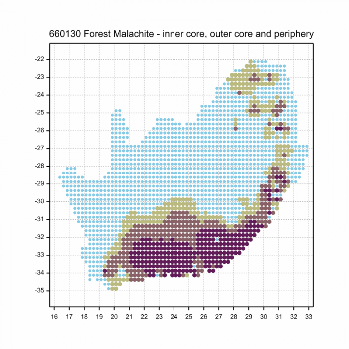
Chlorolestes tessellatus is endemic to South Africa. Its range closely follows the Afromontane forest belt that runs below the escarpment. Distributed from the Riviersonderend Mountains in the Western Cape to the Soutpansberg in Limpopo.
Below is a map showing the distribution of records for Forest Malachite in the OdonataMAP database as at February 2020.

The next map below is an imputed map, produced by an interpolation algorithm, which attempts to generate a full distribution map from the partial information in the map above. This map will be improved by the submission of records to the OdonataMAP section of the Virtual Museum.
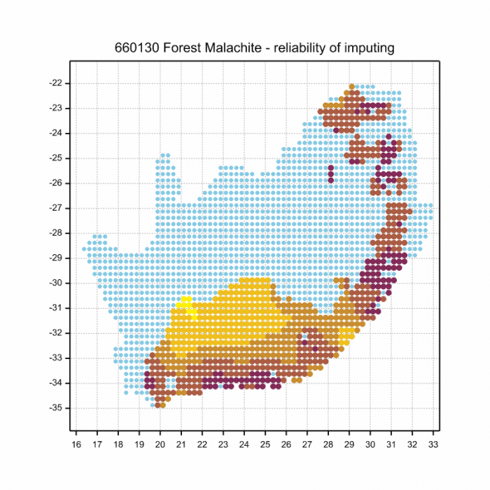
Ultimately, we will produce a series of maps for all the odonata species in the region. The current algorithm is a new algorithm. The objective is mainly to produce “smoothed” maps that could go into a field guide for odonata. This basic version of the algorithm (as mapped above) does not make use of “explanatory variables” (e.g. altitude, terrain roughness, presence of freshwater — we will be producing maps that take these variables into account soon). Currently, it only makes use of the OdonataMAP records for the species being mapped, as well as all the other records of all other species. The basic maps are “optimistic” and will generally show ranges to be larger than what they probably are.
These maps use the data in the OdonataMAP section of the Virtual Museum, and also the database assembled by the previous JRS funded project, which was led by Professor Michael Samways and Dr KD Dijkstra.
Phenology
The next two graphs shows how the occurrence of Forest Malachites varies within the year, i.e. the phenology. There are 268 records in the database for this species, so these results ought to be reliable. The first plot shows the number of records in each pentade, five-day periods, which start on 1 July and end on 30 June the following year. The maximum number of records is in a pentade in March, with 16 records. The blue line is generated by a smoother, an algorithm which aims to separate the “signal” from the “noise”, and shows the pattern of seasonality for this species. The second plot shows only the blue line, and it is scaled to lie between zero and one, for easy comparison between species.


This phenology plot shows that the Forest Malachite has a long flight period, and that it can be encountered throughout the year. However, the main flight period is from December to April. There seems to be a steady build up of numbers mainly in October and November, and rapid decrease in May. The plot is quite strongly bimodal, with two peaks: a main one in early January, and a smaller peak in mid-March.
Lots more records of Forest Malachites in OdonataMAP would confirm whether the bimodality is genuine, or whether it is merely an artefact, attributable to the large number of records in a single pentade in March. If you live anywhere within its large range, please be alert to this species throughout the year, and submit records to OdonataMAP.