
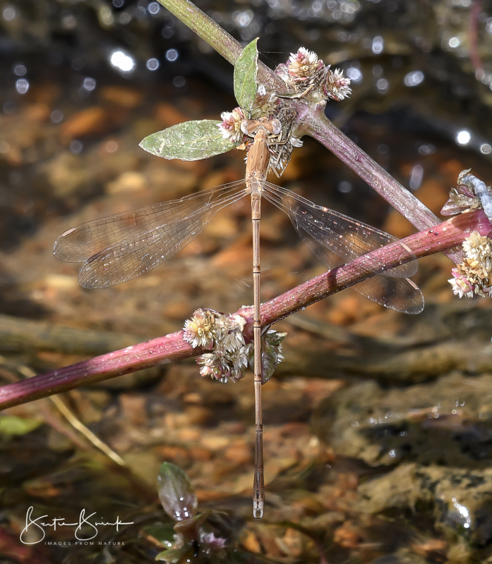
Cover photo by Bertie Brink.
Find the Tawny Spreadwing in the FBIS database (Freshwater Biodiversity Information System) here.
Family Lestidae
Identification
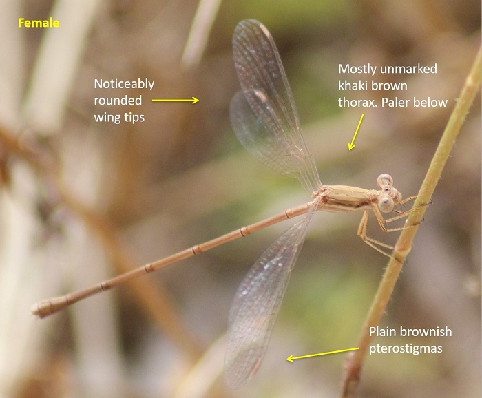
Lusaka Province, Zambia
Photo by Norman Barrett
Small size
Length up to 38mm.
The Tawny Spreadwing is an elongate, drab coloured damselfly with few distinguishing features. It is very similar to the common pale brown form of the Pallid Spreadwing (Lestes pallidus). The Tawny Spreadwing is told apart by having broad, rounded wing tips, plain brownish (not bicoloured) pterostigmas, and in males by the differently shaped claspers that lack inner teeth.
Females closely resemble the males but lack the distinctive claspers.
Click here for more details on identification.
Habitat
The Tawny Spreadwing is a tropical savanna species. It lives near seasonal pools and pans, especially where there is shallowly flooded grass. It occupies similar habitats to Lestes pallidus but seems to prefer more humid savanna regions.
Behaviour
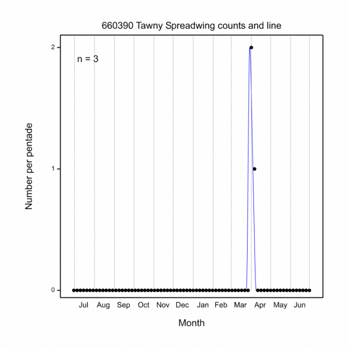
The Tawny Spreadwing is usually found at water where it sits on emergent grass stems with wings outstretched. In South Africa it has been recorded during March and April. See Phenology below.
Status and Conservation
The Tawny Spreadwing is rare in South Africa. It is listed as Vulnerable in the IUCN Red List of Threatened Species.
Distribution
The Tawny Spreadwing is native to the wetter savanna regions of Sub-Saharan Africa. Lestes ictericus is marginal in South Africa where it is only recorded from extreme north-eastern KwaZulu-Natal.
Below is a map showing the distribution of records for Tawny Spreadwing in the OdonataMAP database as at February 2020.
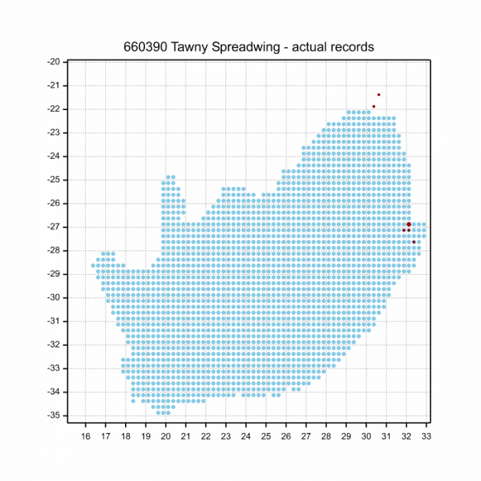
The next map below is an imputed map, produced by an interpolation algorithm, which attempts to generate a full distribution map from the partial information in the map above. This map will be improved by the submission of records to the OdonataMAP section of the Virtual Museum.


Ultimately, we will produce a series of maps for all the odonata species in the region. The current algorithm is a new algorithm. The objective is mainly to produce “smoothed” maps that could go into a field guide for odonata. This basic version of the algorithm (as mapped above) does not make use of “explanatory variables” (e.g. altitude, terrain roughness, presence of freshwater — we will be producing maps that take these variables into account soon). Currently, it only makes use of the OdonataMAP records for the species being mapped, as well as all the other records of all other species. The basic maps are “optimistic” and will generally show ranges to be larger than what they probably are.
These maps use the data in the OdonataMAP section of the Virtual Museum, and also the database assembled by the previous JRS funded project, which was led by Professor Michael Samways and Dr KD Dijkstra.
Phenology
Further Resources
The use of photographs by Bertie Brink and Norman Barrett is acknowledged.
Tawny Spreadwing Lestes ictericus Gerstäcker, 1869
Other Common Names: Yellow Spreadwing (Alt. English); Geelbruinspanvlerkie (Afrikaans).
Recommended citation format: Loftie-Eaton M; Navarro R; Tippett RM; Underhill L. 2025. Tawny Spreadwing Lestes ictericus. Biodiversity and Development Institute. Available online at https://thebdi.org/2020/04/20/tawny-spreadwing-lestes-ictericus/
References: Tarboton, M; Tarboton, W. (2019). A Guide to the Dragonflies & Damselflies of South Africa. Struik Nature.
Samways, MJ. (2008). Dragonflies and Damselflies of South Africa. Pensoft
Samways, MJ. (2016). Manual of Freshwater Assessment for South Africa: Dragonfly Biotic Index. Suricata 2. South African National Biodiversity Institute, Pretoria